News
by Deborah Buehler originally published in Wader Study 129(3)
Spotlight: A 30-year effort to study an elusive bird
The ground gives beneath your feet and you know you have to stop. The wetland surrounding you is also known as a mire, a word that gives fitting connotations of sinking and getting stuck. You look at the bird through binoculars, not daring to go further. It is a small sandpiper with short legs and a long, broad bill with a downturned tip. The English name for this bird is, aptly, Broad-billed Sandpiper. The bird’s Norwegian name is “fjellmyrløper”, which translates to “mountain mire runner”. Now you know why. Instead of flying, it runs through the grass-like sedges ahead of you, almost completely camouflaged. You were lucky to spot it. It probably has a nest out there in that floating vegetation, but you know that going further would not be safe for you or the bird you are trying to study.
[caption id="attachment_16698" align="aligncenter" width="330"]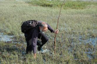 Walking through the mire is a challenge. (photo: Stuart Rae)[/caption]
Given the difficulty of even seeing these elusive birds, it’s no surprise that Broad-billed Sandpipers Calidris falcinellus are not well-studied. Yet, in this issue of Wader Study there are two papers, by the same team of researchers, on this species. One, by Robert Rae and colleagues describes the breeding ecology of these birds.1 The other by Brett Sandercock and colleagues focuses on the adult birds’ physical description and annual survival.2 Both refer to a long-term study that has been in place for nearly 30 years.
When the researchers began the study in 1993 the world was a different place. As they established the study site, Nelson Mandela was elected President of South Africa in the country's first multi-racial elections. When they began to capture, and ring incubating birds eBay was launched. No one “googled” anything and technologies like social media and smart phones were more than a decade away. Yet over all this time, the researchers were walking through the mires, studying Broad-billed Sandpipers.
Broad-billed Sandpipers Calidris falcinellus breed in the subarctic taiga biome and can be divided into two distinct populations: a European subspecies breeding in Fennoscandia (Finland, Norway, Sweden and part of Russia), and an Asian subspecies breeding in central and eastern Russia. Globally, the species has a broad geographic range and a large population size, so it is listed as a species of Least Concern by BirdLife International; however, the population in Europe is decreasing and its conservation status is uncertain.
The researchers set up their long-term study site in the wetlands near Kautokeino, Finnmark in northern Norway, focusing on the European subspecies. Finnmark is situated at the northernmost part of continental Europe, where the Norwegian coastline swings eastward and "East meets West" in terms of geography, culture, and the natural environment.3 Though national bird surveys take place in this region, there are few records of nesting Broad-billed Sandpipers and no demographic data from breeding populations. Traditional survey methods like counting all birds seen or heard in a standard spot (point counts) or walking in a straight line (line transects) tend to overlook the presence of these camouflaged and secretive birds. 4
To remedy this problem, Rae and colleagues began to collect preliminary data in 1993 in order to develop a method to find and study these birds. As expected, nests and incubating birds were difficult to locate. Not only are Broad-billed Sandpipers secretive and solitary, they also “sit tightly,” which means that they are not easily startled (flushed) from their nests when disturbed. Some birds sat tight on their nests even when a person was standing over them. Therefore, each area of mire was searched by walking over it in a meandering route (in contrast to a line transect) to cover all potentially suitable nesting habitat
Once a study area was established, the researchers found as many birds and nests as possible, though some nests had to be monitored from a distance of several metres because they could not be reached safely for the observer or the nest contents. Starting in 1995, Rae and colleagues began to capture incubating adults in nests that could be approached, by laying a mist net over the nest when the adult was sitting on eggs or chicks. The researchers did not trap adults on days with rain or high winds that could chill the eggs while the parent was off the nest and did not observe any cases of nest desertion due to catching birds. Once a bird was captured, aspects of the bird’s body size (biometrics) were measured and the bird was marked with a numbered metal ring and a unique combination of colour rings. Colour-ringing allowed the birds to be recognized (re-sighted) when surveys were conducted in later years, creating encounter histories for each individual bird. Within the encounter history, each year was coded as 1 = captured or re-sighted on the study area, or 0 = not detected during the breeding season.
[caption id="attachment_16697" align="aligncenter" width="330"]
Walking through the mire is a challenge. (photo: Stuart Rae)[/caption]
Given the difficulty of even seeing these elusive birds, it’s no surprise that Broad-billed Sandpipers Calidris falcinellus are not well-studied. Yet, in this issue of Wader Study there are two papers, by the same team of researchers, on this species. One, by Robert Rae and colleagues describes the breeding ecology of these birds.1 The other by Brett Sandercock and colleagues focuses on the adult birds’ physical description and annual survival.2 Both refer to a long-term study that has been in place for nearly 30 years.
When the researchers began the study in 1993 the world was a different place. As they established the study site, Nelson Mandela was elected President of South Africa in the country's first multi-racial elections. When they began to capture, and ring incubating birds eBay was launched. No one “googled” anything and technologies like social media and smart phones were more than a decade away. Yet over all this time, the researchers were walking through the mires, studying Broad-billed Sandpipers.
Broad-billed Sandpipers Calidris falcinellus breed in the subarctic taiga biome and can be divided into two distinct populations: a European subspecies breeding in Fennoscandia (Finland, Norway, Sweden and part of Russia), and an Asian subspecies breeding in central and eastern Russia. Globally, the species has a broad geographic range and a large population size, so it is listed as a species of Least Concern by BirdLife International; however, the population in Europe is decreasing and its conservation status is uncertain.
The researchers set up their long-term study site in the wetlands near Kautokeino, Finnmark in northern Norway, focusing on the European subspecies. Finnmark is situated at the northernmost part of continental Europe, where the Norwegian coastline swings eastward and "East meets West" in terms of geography, culture, and the natural environment.3 Though national bird surveys take place in this region, there are few records of nesting Broad-billed Sandpipers and no demographic data from breeding populations. Traditional survey methods like counting all birds seen or heard in a standard spot (point counts) or walking in a straight line (line transects) tend to overlook the presence of these camouflaged and secretive birds. 4
To remedy this problem, Rae and colleagues began to collect preliminary data in 1993 in order to develop a method to find and study these birds. As expected, nests and incubating birds were difficult to locate. Not only are Broad-billed Sandpipers secretive and solitary, they also “sit tightly,” which means that they are not easily startled (flushed) from their nests when disturbed. Some birds sat tight on their nests even when a person was standing over them. Therefore, each area of mire was searched by walking over it in a meandering route (in contrast to a line transect) to cover all potentially suitable nesting habitat
Once a study area was established, the researchers found as many birds and nests as possible, though some nests had to be monitored from a distance of several metres because they could not be reached safely for the observer or the nest contents. Starting in 1995, Rae and colleagues began to capture incubating adults in nests that could be approached, by laying a mist net over the nest when the adult was sitting on eggs or chicks. The researchers did not trap adults on days with rain or high winds that could chill the eggs while the parent was off the nest and did not observe any cases of nest desertion due to catching birds. Once a bird was captured, aspects of the bird’s body size (biometrics) were measured and the bird was marked with a numbered metal ring and a unique combination of colour rings. Colour-ringing allowed the birds to be recognized (re-sighted) when surveys were conducted in later years, creating encounter histories for each individual bird. Within the encounter history, each year was coded as 1 = captured or re-sighted on the study area, or 0 = not detected during the breeding season.
[caption id="attachment_16697" align="aligncenter" width="330"]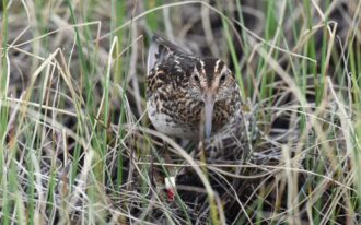 Well camouflaged and colour ringed Broad-billed Sandpiper. (photo: Stuart Rae)[/caption]
The researchers used this study protocol every year from 1995-2019 to survey 10-14 days in the 3-week period between 15 June and 8 July. From 2000-2019, they further mapped local conditions around the nest sites (in later years using GPS coordinates) so that the same areas could be checked in subsequent years to locate pairs reusing the same location. From 2009-2019, they conducted intensive monitoring with experienced observers returning to all sites two or more times during the incubation period to estimate nest survival.
All those years of fieldwork paid off. Rae and colleagues found a total of 173 Broad-billed Sandpiper nests from 2000-2019, with an average of 8 per year, but varying between 2-16. Nests were typically set in a shallow depression (scrape) on a tussock (tuft) of vegetation or mossy hummock and lined with dry dead sedge. All of the nests were located in or on the edge of floating vegetation within the mires and only 5-10 cm above the water level. No other bird species was found nesting in this way or in these habitats. The birds were also very faithful to their nest site. Of the breeding birds that returned in subsequent years, 97% nested in the same mire and many pairs reused the same nest scrape.
[caption id="attachment_16696" align="aligncenter" width="330"]
Well camouflaged and colour ringed Broad-billed Sandpiper. (photo: Stuart Rae)[/caption]
The researchers used this study protocol every year from 1995-2019 to survey 10-14 days in the 3-week period between 15 June and 8 July. From 2000-2019, they further mapped local conditions around the nest sites (in later years using GPS coordinates) so that the same areas could be checked in subsequent years to locate pairs reusing the same location. From 2009-2019, they conducted intensive monitoring with experienced observers returning to all sites two or more times during the incubation period to estimate nest survival.
All those years of fieldwork paid off. Rae and colleagues found a total of 173 Broad-billed Sandpiper nests from 2000-2019, with an average of 8 per year, but varying between 2-16. Nests were typically set in a shallow depression (scrape) on a tussock (tuft) of vegetation or mossy hummock and lined with dry dead sedge. All of the nests were located in or on the edge of floating vegetation within the mires and only 5-10 cm above the water level. No other bird species was found nesting in this way or in these habitats. The birds were also very faithful to their nest site. Of the breeding birds that returned in subsequent years, 97% nested in the same mire and many pairs reused the same nest scrape.
[caption id="attachment_16696" align="aligncenter" width="330"]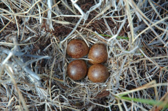 Broad-billed Sandpiper nest. (photo: Stuart Rae)[/caption]
The average date for egg laying in years 2009-2019 was 10 June and varied between 1-24 June. Rae and colleagues were able to check the contents of 156 nests and found that 94% of these had four eggs, which is typical in shorebirds. They were further able to monitor the fate of 91 nests and recorded six losses due to flooding, one to predation and one from an unknown cause. Like most shorebird species, the males mainly took care of hatched young. The strategy of nesting on floating vegetation resulted in high nest success and low predation rates but left the nests vulnerable to flooding. Nest placement has conservation implications, especially if rainstorms fueled by climate change cause water levels to rise rapidly, threatening breeding success.
Rae and colleagues ringed and re-sighted 119 Broad-billed Sandpipers during the breeding seasons of 1995-2019. They found annual survival rates that were typical for small-bodied waders. Estimated survival rates did not differ between the sexes, but were lower among first-year than older birds, and highest among previously marked birds that had returned to the study site at least once. Biometric measurements of body size showed that, like in most species of shorebirds, females are larger than males, and that in Broad-billed Sandpipers the difference in size is greatest for bill length. Bill length affects feeding behaviour (pecking and probing for food) and in other shorebird species, this sometimes leads to males and females using different habitats and sometimes even different latitudes in the non-breeding season. Testing whether this might also be true for Broad-billed Sandpipers will require studies of feeding ecology on the non-breeding grounds.
Finally, the researchers captured three birds that had been caught and ringed elsewhere during migration (foreign recaptures). They were able to compare biometric measurements from these birds with similar data from birds breeding in the study site. These data suggested that birds breeding in Norway are part of the same population as birds stopping in the Sivash in eastern Europe during spring migration.5 The stopover area in the Sivash is located in the contested Crimean Peninsula. When this study began, Crimea was part of Ukraine and early fieldwork in both Norway and Sivash were underway. Two decades later in 2014, while the work in the breeding areas continued, Russia annexed the Crimea. This past year (2022), the Sivash is again in the middle of a war zone and one wonders about the fate of the birds, and of colleagues on both sides of the conflict.
The Sivash is not the only part of the Broad-billed Sandpiper flyway under threat. The researchers point out that poorly-studied nonbreeding habitats are also vulnerable to expanding human development. Future work will focus on tracking birds with geolocators, tiny tags that record ambient light level (solar irradiance) to determine the bird’s location. The tracking tags will allow researchers to gather better data on which habitats are critical in the nonbreeding range and might even allow data collection to continue when a site becomes inaccessible for on-the-ground study.
Thirty years is a long time. The internet rose, the Twin Towers in New York fell, wars began and ceased, and through it all these researchers walked carefully through the mires of northern Norway studying small sandpipers with short legs and strange bills. Their persistence and long-standing international cooperation provide more than just data about a poorly-studied bird species. In an increasingly fast-paced and divided world, this type of collaboration provides hope.
1 Rae, R, S Rae, B. K. Sandercock & D. P. Whitfield. 2022. The breeding ecology of Broad-billed Sandpipers in northern Norway. Wader Study 129: 183–189.
2 Sandercock, B. K., R. Rae, S Rae, & D. P. Whitfield. 2022. Sexual size dimorphism, disassortative pairing, and annual survival of Broad-billed Sandpipers in northern Norway. Wader Study 129: 194–206.
3 Finmmark. (2022, December 19). In Wikipedia. https://en.wikipedia.org/wiki/Finnmark#:~:text=Situated%20at%20the%20northernmost%20part,of%20Saint%20Petersburg%20and%20Istanbul.
4 Hildén, O. 1981. Sources of error involved in the Finnish line-transect method. Studies in Avian Biology 6: 152-159.
5 Verkuil, Y., T.M. Van der Have, J. Van der Winden, G.O. Keijl, P.S. Ruiters, A. Koolhaas, A. Dekinga & Chernichko, II. 2006. Fast fuelling but light flight in Broad-billed Sandpipers Limicola falcinellus: stopover ecology at a final take-off site in spring (Sivash, Ukraine). Ibis 148: 211-220.
PDF of this article
Broad-billed Sandpiper nest. (photo: Stuart Rae)[/caption]
The average date for egg laying in years 2009-2019 was 10 June and varied between 1-24 June. Rae and colleagues were able to check the contents of 156 nests and found that 94% of these had four eggs, which is typical in shorebirds. They were further able to monitor the fate of 91 nests and recorded six losses due to flooding, one to predation and one from an unknown cause. Like most shorebird species, the males mainly took care of hatched young. The strategy of nesting on floating vegetation resulted in high nest success and low predation rates but left the nests vulnerable to flooding. Nest placement has conservation implications, especially if rainstorms fueled by climate change cause water levels to rise rapidly, threatening breeding success.
Rae and colleagues ringed and re-sighted 119 Broad-billed Sandpipers during the breeding seasons of 1995-2019. They found annual survival rates that were typical for small-bodied waders. Estimated survival rates did not differ between the sexes, but were lower among first-year than older birds, and highest among previously marked birds that had returned to the study site at least once. Biometric measurements of body size showed that, like in most species of shorebirds, females are larger than males, and that in Broad-billed Sandpipers the difference in size is greatest for bill length. Bill length affects feeding behaviour (pecking and probing for food) and in other shorebird species, this sometimes leads to males and females using different habitats and sometimes even different latitudes in the non-breeding season. Testing whether this might also be true for Broad-billed Sandpipers will require studies of feeding ecology on the non-breeding grounds.
Finally, the researchers captured three birds that had been caught and ringed elsewhere during migration (foreign recaptures). They were able to compare biometric measurements from these birds with similar data from birds breeding in the study site. These data suggested that birds breeding in Norway are part of the same population as birds stopping in the Sivash in eastern Europe during spring migration.5 The stopover area in the Sivash is located in the contested Crimean Peninsula. When this study began, Crimea was part of Ukraine and early fieldwork in both Norway and Sivash were underway. Two decades later in 2014, while the work in the breeding areas continued, Russia annexed the Crimea. This past year (2022), the Sivash is again in the middle of a war zone and one wonders about the fate of the birds, and of colleagues on both sides of the conflict.
The Sivash is not the only part of the Broad-billed Sandpiper flyway under threat. The researchers point out that poorly-studied nonbreeding habitats are also vulnerable to expanding human development. Future work will focus on tracking birds with geolocators, tiny tags that record ambient light level (solar irradiance) to determine the bird’s location. The tracking tags will allow researchers to gather better data on which habitats are critical in the nonbreeding range and might even allow data collection to continue when a site becomes inaccessible for on-the-ground study.
Thirty years is a long time. The internet rose, the Twin Towers in New York fell, wars began and ceased, and through it all these researchers walked carefully through the mires of northern Norway studying small sandpipers with short legs and strange bills. Their persistence and long-standing international cooperation provide more than just data about a poorly-studied bird species. In an increasingly fast-paced and divided world, this type of collaboration provides hope.
1 Rae, R, S Rae, B. K. Sandercock & D. P. Whitfield. 2022. The breeding ecology of Broad-billed Sandpipers in northern Norway. Wader Study 129: 183–189.
2 Sandercock, B. K., R. Rae, S Rae, & D. P. Whitfield. 2022. Sexual size dimorphism, disassortative pairing, and annual survival of Broad-billed Sandpipers in northern Norway. Wader Study 129: 194–206.
3 Finmmark. (2022, December 19). In Wikipedia. https://en.wikipedia.org/wiki/Finnmark#:~:text=Situated%20at%20the%20northernmost%20part,of%20Saint%20Petersburg%20and%20Istanbul.
4 Hildén, O. 1981. Sources of error involved in the Finnish line-transect method. Studies in Avian Biology 6: 152-159.
5 Verkuil, Y., T.M. Van der Have, J. Van der Winden, G.O. Keijl, P.S. Ruiters, A. Koolhaas, A. Dekinga & Chernichko, II. 2006. Fast fuelling but light flight in Broad-billed Sandpipers Limicola falcinellus: stopover ecology at a final take-off site in spring (Sivash, Ukraine). Ibis 148: 211-220.
PDF of this article
Walking through the mire is a challenge. (photo: Stuart Rae)[/caption]
Given the difficulty of even seeing these elusive birds, it’s no surprise that Broad-billed Sandpipers Calidris falcinellus are not well-studied. Yet, in this issue of Wader Study there are two papers, by the same team of researchers, on this species. One, by Robert Rae and colleagues describes the breeding ecology of these birds.1 The other by Brett Sandercock and colleagues focuses on the adult birds’ physical description and annual survival.2 Both refer to a long-term study that has been in place for nearly 30 years.
When the researchers began the study in 1993 the world was a different place. As they established the study site, Nelson Mandela was elected President of South Africa in the country's first multi-racial elections. When they began to capture, and ring incubating birds eBay was launched. No one “googled” anything and technologies like social media and smart phones were more than a decade away. Yet over all this time, the researchers were walking through the mires, studying Broad-billed Sandpipers.
Broad-billed Sandpipers Calidris falcinellus breed in the subarctic taiga biome and can be divided into two distinct populations: a European subspecies breeding in Fennoscandia (Finland, Norway, Sweden and part of Russia), and an Asian subspecies breeding in central and eastern Russia. Globally, the species has a broad geographic range and a large population size, so it is listed as a species of Least Concern by BirdLife International; however, the population in Europe is decreasing and its conservation status is uncertain.
The researchers set up their long-term study site in the wetlands near Kautokeino, Finnmark in northern Norway, focusing on the European subspecies. Finnmark is situated at the northernmost part of continental Europe, where the Norwegian coastline swings eastward and "East meets West" in terms of geography, culture, and the natural environment.3 Though national bird surveys take place in this region, there are few records of nesting Broad-billed Sandpipers and no demographic data from breeding populations. Traditional survey methods like counting all birds seen or heard in a standard spot (point counts) or walking in a straight line (line transects) tend to overlook the presence of these camouflaged and secretive birds. 4
To remedy this problem, Rae and colleagues began to collect preliminary data in 1993 in order to develop a method to find and study these birds. As expected, nests and incubating birds were difficult to locate. Not only are Broad-billed Sandpipers secretive and solitary, they also “sit tightly,” which means that they are not easily startled (flushed) from their nests when disturbed. Some birds sat tight on their nests even when a person was standing over them. Therefore, each area of mire was searched by walking over it in a meandering route (in contrast to a line transect) to cover all potentially suitable nesting habitat
Once a study area was established, the researchers found as many birds and nests as possible, though some nests had to be monitored from a distance of several metres because they could not be reached safely for the observer or the nest contents. Starting in 1995, Rae and colleagues began to capture incubating adults in nests that could be approached, by laying a mist net over the nest when the adult was sitting on eggs or chicks. The researchers did not trap adults on days with rain or high winds that could chill the eggs while the parent was off the nest and did not observe any cases of nest desertion due to catching birds. Once a bird was captured, aspects of the bird’s body size (biometrics) were measured and the bird was marked with a numbered metal ring and a unique combination of colour rings. Colour-ringing allowed the birds to be recognized (re-sighted) when surveys were conducted in later years, creating encounter histories for each individual bird. Within the encounter history, each year was coded as 1 = captured or re-sighted on the study area, or 0 = not detected during the breeding season.
[caption id="attachment_16697" align="aligncenter" width="330"] Well camouflaged and colour ringed Broad-billed Sandpiper. (photo: Stuart Rae)[/caption]
The researchers used this study protocol every year from 1995-2019 to survey 10-14 days in the 3-week period between 15 June and 8 July. From 2000-2019, they further mapped local conditions around the nest sites (in later years using GPS coordinates) so that the same areas could be checked in subsequent years to locate pairs reusing the same location. From 2009-2019, they conducted intensive monitoring with experienced observers returning to all sites two or more times during the incubation period to estimate nest survival.
All those years of fieldwork paid off. Rae and colleagues found a total of 173 Broad-billed Sandpiper nests from 2000-2019, with an average of 8 per year, but varying between 2-16. Nests were typically set in a shallow depression (scrape) on a tussock (tuft) of vegetation or mossy hummock and lined with dry dead sedge. All of the nests were located in or on the edge of floating vegetation within the mires and only 5-10 cm above the water level. No other bird species was found nesting in this way or in these habitats. The birds were also very faithful to their nest site. Of the breeding birds that returned in subsequent years, 97% nested in the same mire and many pairs reused the same nest scrape.
[caption id="attachment_16696" align="aligncenter" width="330"] Broad-billed Sandpiper nest. (photo: Stuart Rae)[/caption]
The average date for egg laying in years 2009-2019 was 10 June and varied between 1-24 June. Rae and colleagues were able to check the contents of 156 nests and found that 94% of these had four eggs, which is typical in shorebirds. They were further able to monitor the fate of 91 nests and recorded six losses due to flooding, one to predation and one from an unknown cause. Like most shorebird species, the males mainly took care of hatched young. The strategy of nesting on floating vegetation resulted in high nest success and low predation rates but left the nests vulnerable to flooding. Nest placement has conservation implications, especially if rainstorms fueled by climate change cause water levels to rise rapidly, threatening breeding success.
Rae and colleagues ringed and re-sighted 119 Broad-billed Sandpipers during the breeding seasons of 1995-2019. They found annual survival rates that were typical for small-bodied waders. Estimated survival rates did not differ between the sexes, but were lower among first-year than older birds, and highest among previously marked birds that had returned to the study site at least once. Biometric measurements of body size showed that, like in most species of shorebirds, females are larger than males, and that in Broad-billed Sandpipers the difference in size is greatest for bill length. Bill length affects feeding behaviour (pecking and probing for food) and in other shorebird species, this sometimes leads to males and females using different habitats and sometimes even different latitudes in the non-breeding season. Testing whether this might also be true for Broad-billed Sandpipers will require studies of feeding ecology on the non-breeding grounds.
Finally, the researchers captured three birds that had been caught and ringed elsewhere during migration (foreign recaptures). They were able to compare biometric measurements from these birds with similar data from birds breeding in the study site. These data suggested that birds breeding in Norway are part of the same population as birds stopping in the Sivash in eastern Europe during spring migration.5 The stopover area in the Sivash is located in the contested Crimean Peninsula. When this study began, Crimea was part of Ukraine and early fieldwork in both Norway and Sivash were underway. Two decades later in 2014, while the work in the breeding areas continued, Russia annexed the Crimea. This past year (2022), the Sivash is again in the middle of a war zone and one wonders about the fate of the birds, and of colleagues on both sides of the conflict.
The Sivash is not the only part of the Broad-billed Sandpiper flyway under threat. The researchers point out that poorly-studied nonbreeding habitats are also vulnerable to expanding human development. Future work will focus on tracking birds with geolocators, tiny tags that record ambient light level (solar irradiance) to determine the bird’s location. The tracking tags will allow researchers to gather better data on which habitats are critical in the nonbreeding range and might even allow data collection to continue when a site becomes inaccessible for on-the-ground study.
Thirty years is a long time. The internet rose, the Twin Towers in New York fell, wars began and ceased, and through it all these researchers walked carefully through the mires of northern Norway studying small sandpipers with short legs and strange bills. Their persistence and long-standing international cooperation provide more than just data about a poorly-studied bird species. In an increasingly fast-paced and divided world, this type of collaboration provides hope.
1 Rae, R, S Rae, B. K. Sandercock & D. P. Whitfield. 2022. The breeding ecology of Broad-billed Sandpipers in northern Norway. Wader Study 129: 183–189.
2 Sandercock, B. K., R. Rae, S Rae, & D. P. Whitfield. 2022. Sexual size dimorphism, disassortative pairing, and annual survival of Broad-billed Sandpipers in northern Norway. Wader Study 129: 194–206.
3 Finmmark. (2022, December 19). In Wikipedia. https://en.wikipedia.org/wiki/Finnmark#:~:text=Situated%20at%20the%20northernmost%20part,of%20Saint%20Petersburg%20and%20Istanbul.
4 Hildén, O. 1981. Sources of error involved in the Finnish line-transect method. Studies in Avian Biology 6: 152-159.
5 Verkuil, Y., T.M. Van der Have, J. Van der Winden, G.O. Keijl, P.S. Ruiters, A. Koolhaas, A. Dekinga & Chernichko, II. 2006. Fast fuelling but light flight in Broad-billed Sandpipers Limicola falcinellus: stopover ecology at a final take-off site in spring (Sivash, Ukraine). Ibis 148: 211-220.
PDF of this article Spotlight: A 30-year effort to study an elusive bird
Posted by Gwenaël Quaintenne on 24 January 2023
by Deborah Buehler originally published in Wader Study 129(3) Spotlight: A 30-year effort to study an elusive bird The ground gives beneath your feet and you know you have to stop. The wetland surrounding you is also known as a mire, a word that gives fitting connotations of sinking and getting stuck. You look at the bird through binoculars, not daring to go further. It is a small sandpiper with short legs and a long, broad bill with a downturned tip. The English name for this bird is, aptly,
The 2023 annual conference will be held at the Wadden Sea island of Sylt, Germany.
For more information, please consult the conference webpage:
[embed]https://www.waderstudygroup.org/conferences/2023-sylt-germany/[/embed]
Save the date! 2023 IWSG conference: 29 September – 03 October 2023 Sylt, Germany
Posted by Gwenaël Quaintenne on 7 December 2022
The 2023 annual conference will be held at the Wadden Sea island of Sylt, Germany. For more information, please consult the conference webpage:
by Deborah Buehler originally published in Wader Study 129(2)
Migrant birds move to get what they need.
Shorebird migration to exploit seasonally fluctuating resources has been studied for years and researchers have mapped globe-spanning networks of places where birds reproduce at breeding areas, refuel at stopover sites, and spend the non-breeding season at wintering areas. Still, new sites of importance continue to be found and growing datasets compiling bird sightings over decades are integral to this work. Even within a site, migrants move to exploit resources, and much remains to be discovered at these smaller geographic and shorter-time scales.
In this issue of Wader Study, two papers examine migrant movements on opposite sides of the Atlantic and at different scales. Both highlight the overlooked significance of relatively small sites for the health of shorebirds along a larger flyway. Mary Pelton, Sara Padula and colleagues document the importance of the Kiawah and Seabrook islands in South Carolina, USA using surveys and modelling to provide population estimates for Red Knots, Calidris canutus rufa.1 Clément Jourdan and colleagues use GPS telemetry to analyse the movements and behaviour of wintering Black-tailed Godwits Limosa limosa islandica in France and describe the birds’ use of wetlands over different temporal scales.2
In South Carolina, the researchers focused on a subspecies of Red Knot. Rufa knots are listed as threatened in both Canada and the United States due to an 85% population decline over the past few decades. The researchers’ goal was to estimate the number of rufa knots using a 24-km stretch of sandy beach in the Kiawah-Seabrook Island complex (hereafter KSI) and to further understand where they came from, where they were going, and whether some birds used the site throughout the non-breeding season.
[caption id="attachment_16474" align="aligncenter" width="700"] Scanning for colour-marked birds during surveys (photo: Mary Margaret Pelton)[/caption]
To do this, they conducted on-the-ground surveys between 19 February and 20 May 2021. Prior to this, they also deployed geolocators on birds captured at the site between April 2015 and May 2016. Geolocators periodically record ambient light level (solar irradiance) to determine location; however, the bird needs to be recaptured to download the data. Although a total of 33 geolocators were deployed, only three were retrieved as part of this study.
When shorebirds are captured in North and South America, they are marked with flags consisting of a unique alphanumeric code. Marking follows the Pan American Shorebird Group protocol,3 and flags are colour coded to the area the bird was first marked; for example, Canada (white), the United States (green), Argentina (orange). When the bird is seen again, researchers know at a glance where the bird was first marked and can identify the individual by the code. In their surveys, the researchers in South Carolina recorded the presence of birds that had been previously marked, and they sometimes saw the same birds multiple times over the season. This is called resighting. They also estimated the ratio of marked to unmarked birds. This information allowed them to use statistical models to estimate the number of birds passing through the area (passage population) and how long they stayed (stopover duration).
KSI lies south of Delaware Bay, which has historically been regarded as the last steppingstone for birds migrating from further south to refuel before departing for their Arctic breeding grounds. However, mounting evidence in the past decade shows that birds likely use a suite of stopover sites, not Delaware Bay alone. Because shorebird marking has been standardized in the Americas since the mid-1980s, the researchers had access to an online database, www.bandedbirds.org, containing decades of data. Using this resource, they analysed previous capture and resighting data for all of the 217 uniquely flagged birds they resighted during their 13-week study. This work revealed that the birds had accessed a network of more than 70 sites spanning Texas to Florida to Massachusetts in the USA, as well as Ontario (James Bay) and Quebec in Canada. Results from the three geolocator-carrying birds also indicated that Delaware Bay was not be the only place to rest before leaving for the Arctic. All three birds skipped Delaware Bay after stopping in South Carolina.
The researchers also found evidence that rufa knots might be using KSI for overwintering as well as stopover. First, their surveys indicated an estimated ~2,400 birds present at KSI as early as 19 Feb, and many were subsequently observed again in May, suggesting that they had stayed throughout the winter. Second, as the season progressed the number of birds increased, indicating an influx of new birds from further south. Thus, KSI likely supports two groups of rufa knots: those that spend the non-breeding season there, and those that migrate through, using the site as a stopover. The idea that distinct groups might exist within the rufa subspecies is not new. Major nonbreeding clusters of rufa knots have been found in the south-eastern USA (Florida and Texas), north-central Brazil, and Tierra del Fuego. Genetic work by Yvonne Verkuil and colleagues described evidence that suggests that these groups might also be genetically different.4
Importantly, the statistical modelling indicated a minimum of 17,000 rufa Red Knots (over 40% of the total population) used KSI during their study period. Combined with other findings, this provides ample evidence that KSI is important along the flyway as a stopover and overwintering site for rufa Red Knots. The site is also important for other shorebird species. Another recent study reported a nocturnal roost supporting nearly half of the Atlantic Flyway population of Hudsonian Whimbrel Numenius hudsonicus on Deveaux Bank, right next to KSI.5 The authors recommend the nomination of KSI and neighbouring Deveaux Bank as a Site of Hemispheric Importance in the Western Hemisphere Shorebird Reserve Network.
On the other side of the Atlantic, in France, Clément Jourdan and colleagues were focused on another long-distance migrant, the Black-tailed Godwit. Unlike rufa knots, the population of the islandica godwit subspecies has been increasing for several decades. They are omnivorous and able to exploit multiple habitats, making them ideal for studying habitat choice in wintering sites over different temporal scales. The researchers worked on the French Atlantic coast focusing on wintering habitats within a 6,000 km2 area including the Loire Estuary, Bourgneuf Bay, the Vendée Coast, and the Pertuis Charentais area, where most of France’s Black-tailed Godwits spend the non-breeding season.
The goal was to describe how birds used the space at a single wintering site by identifying the most-used habitat for each individual on each monitoring day, then investigating when birds changed their daily most-used habitat over the season. The researchers also studied habitat choice across the span of a single day (within days) to describe habitat shifts over 24-hour periods. They used an existing system to classify the habitat types and focused on ‘cropping systems’ (i.e., arable land), ‘inland marshes’, ‘coastal marshes’, ‘saltpans’, ‘bare mudflats’ and ‘other habitats’ (i.e., land not normally used by godwits) for this study.
The researchers used GPS telemetry to track the birds’ movements. To install the GPS tags, birds were captured at night with mist nets set on their high tide roosts between November 2016 and October 2018. All birds were weighed, measured, and their age and sex were determined. They were then marked with a metal ring and a unique colour ring combination. GPS tags were fitted to the heaviest individuals only, so as not to exceed 3% of the bird’s body mass. The GPS tags recorded location every thirty minutes or so and with an accuracy of plus or minus ten meters. The researchers only used data from godwits with at least one month of wintering data on the Central French Atlantic coast for this study. Ten birds fit these criteria and were monitored from 3 March 2016 to 24 April 2020.
[caption id="attachment_16475" align="aligncenter" width="700"]
Scanning for colour-marked birds during surveys (photo: Mary Margaret Pelton)[/caption]
To do this, they conducted on-the-ground surveys between 19 February and 20 May 2021. Prior to this, they also deployed geolocators on birds captured at the site between April 2015 and May 2016. Geolocators periodically record ambient light level (solar irradiance) to determine location; however, the bird needs to be recaptured to download the data. Although a total of 33 geolocators were deployed, only three were retrieved as part of this study.
When shorebirds are captured in North and South America, they are marked with flags consisting of a unique alphanumeric code. Marking follows the Pan American Shorebird Group protocol,3 and flags are colour coded to the area the bird was first marked; for example, Canada (white), the United States (green), Argentina (orange). When the bird is seen again, researchers know at a glance where the bird was first marked and can identify the individual by the code. In their surveys, the researchers in South Carolina recorded the presence of birds that had been previously marked, and they sometimes saw the same birds multiple times over the season. This is called resighting. They also estimated the ratio of marked to unmarked birds. This information allowed them to use statistical models to estimate the number of birds passing through the area (passage population) and how long they stayed (stopover duration).
KSI lies south of Delaware Bay, which has historically been regarded as the last steppingstone for birds migrating from further south to refuel before departing for their Arctic breeding grounds. However, mounting evidence in the past decade shows that birds likely use a suite of stopover sites, not Delaware Bay alone. Because shorebird marking has been standardized in the Americas since the mid-1980s, the researchers had access to an online database, www.bandedbirds.org, containing decades of data. Using this resource, they analysed previous capture and resighting data for all of the 217 uniquely flagged birds they resighted during their 13-week study. This work revealed that the birds had accessed a network of more than 70 sites spanning Texas to Florida to Massachusetts in the USA, as well as Ontario (James Bay) and Quebec in Canada. Results from the three geolocator-carrying birds also indicated that Delaware Bay was not be the only place to rest before leaving for the Arctic. All three birds skipped Delaware Bay after stopping in South Carolina.
The researchers also found evidence that rufa knots might be using KSI for overwintering as well as stopover. First, their surveys indicated an estimated ~2,400 birds present at KSI as early as 19 Feb, and many were subsequently observed again in May, suggesting that they had stayed throughout the winter. Second, as the season progressed the number of birds increased, indicating an influx of new birds from further south. Thus, KSI likely supports two groups of rufa knots: those that spend the non-breeding season there, and those that migrate through, using the site as a stopover. The idea that distinct groups might exist within the rufa subspecies is not new. Major nonbreeding clusters of rufa knots have been found in the south-eastern USA (Florida and Texas), north-central Brazil, and Tierra del Fuego. Genetic work by Yvonne Verkuil and colleagues described evidence that suggests that these groups might also be genetically different.4
Importantly, the statistical modelling indicated a minimum of 17,000 rufa Red Knots (over 40% of the total population) used KSI during their study period. Combined with other findings, this provides ample evidence that KSI is important along the flyway as a stopover and overwintering site for rufa Red Knots. The site is also important for other shorebird species. Another recent study reported a nocturnal roost supporting nearly half of the Atlantic Flyway population of Hudsonian Whimbrel Numenius hudsonicus on Deveaux Bank, right next to KSI.5 The authors recommend the nomination of KSI and neighbouring Deveaux Bank as a Site of Hemispheric Importance in the Western Hemisphere Shorebird Reserve Network.
On the other side of the Atlantic, in France, Clément Jourdan and colleagues were focused on another long-distance migrant, the Black-tailed Godwit. Unlike rufa knots, the population of the islandica godwit subspecies has been increasing for several decades. They are omnivorous and able to exploit multiple habitats, making them ideal for studying habitat choice in wintering sites over different temporal scales. The researchers worked on the French Atlantic coast focusing on wintering habitats within a 6,000 km2 area including the Loire Estuary, Bourgneuf Bay, the Vendée Coast, and the Pertuis Charentais area, where most of France’s Black-tailed Godwits spend the non-breeding season.
The goal was to describe how birds used the space at a single wintering site by identifying the most-used habitat for each individual on each monitoring day, then investigating when birds changed their daily most-used habitat over the season. The researchers also studied habitat choice across the span of a single day (within days) to describe habitat shifts over 24-hour periods. They used an existing system to classify the habitat types and focused on ‘cropping systems’ (i.e., arable land), ‘inland marshes’, ‘coastal marshes’, ‘saltpans’, ‘bare mudflats’ and ‘other habitats’ (i.e., land not normally used by godwits) for this study.
The researchers used GPS telemetry to track the birds’ movements. To install the GPS tags, birds were captured at night with mist nets set on their high tide roosts between November 2016 and October 2018. All birds were weighed, measured, and their age and sex were determined. They were then marked with a metal ring and a unique colour ring combination. GPS tags were fitted to the heaviest individuals only, so as not to exceed 3% of the bird’s body mass. The GPS tags recorded location every thirty minutes or so and with an accuracy of plus or minus ten meters. The researchers only used data from godwits with at least one month of wintering data on the Central French Atlantic coast for this study. Ten birds fit these criteria and were monitored from 3 March 2016 to 24 April 2020.
[caption id="attachment_16475" align="aligncenter" width="700"]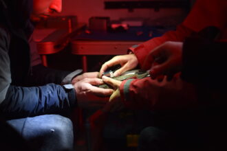 Deploying a GPS tag (photo: Thierry Guyot)[/caption]
At the level of habitat choice over a season, Jourdan and colleagues found that most islandica godwits used intertidal areas from early to mid-winter, then moved to inland marshes just before the spring migration period. This finding supports previous work which has shown this shift, with authors suggesting that it occurs in response to seasonal prey depletion on intertidal habitats. The birds move inland to habitats to follow the abundance of food.
At the level of habitat shifts within a day, habitat use in coastal areas depended on the tide. Birds fed in intertidal habitats like ‘bare mudflats’ at low tide and used the coastal marshes to rest (roost) at high tide regardless of time of day. When using inland habitats, like ‘inland marshes’, they were often observed roosting during the day, with feeding activity occurring mainly at night. One interesting observation was the birds’ use of hunting ponds. Hunters attract ducks to these ponds and hunt them at night between early August and late January. During the hunting season, the researchers found that shorebirds mainly exploited these ponds during the day, but after the hunt closed, the birds used the ‘hunting ponds’ both day and night.
Migrant birds move around – a lot – and they do this at varying space and time scales. Pelton, Padula and colleagues explored this at the level of a chain of stopover and wintering sites on the Atlantic coast of the United States. On the other side of the ocean, Jourdan and colleagues looked at how birds shift between different habitat types within a wintering area. Half a world away in India, researchers are starting to gather data for what will hopefully be another long standing dataset of captures and resightings.6 These studies show that there is much yet to discover about migrant shorebirds in terms of where they go, when they go and why those places they stop at are important.
1 Pelton, M.M., S. R. Padula, J. Garcia-Walther, M. Andrews, R. Mercer, R. Porter, F. Sanders, J. Thibault, N. R. Senner & J. A. Linscott. 2022. Kiawah and Seabrook islands are a critical site for the rufa Red Knot (Calidris canutus rufa). Wader Study 129: 105–118.
2 Jourdan, C., J. Fort, F. Robin, D. Pinaud, P. Delaporte, D. Desmots, A. Gentric, P. Lagrange, J. Gernigon, L. Jomat, P. Rousseau & P. Bocher. 2022. Combination of marine and freshwater artificial habitats provide wintering Black-tailed Godwits with landscape supplementation. Wader Study 129: 86–99.
3 Pan American Shorebird Group. 2016. Pan American Shorebird Program Shorebird Marking Protocol. https://www.shorebirdplan.org/wp-content/uploads/2016/08/PASP-Marking-Protocol-April-2016.pdf
4 Verkuil, Y.I., E. Tavares, P.M. González, K. Choffe, O. Haddrath, M. Peck, L.J. Niles, A.J. Baker, T. Piersma & J.R. Conklin. 2021. Genetic structure in the nonbreeding range of rufa Red Knots suggests distinct Arctic breeding populations. Ornithological Applications 124: duab053.
5 Sanders, F.J., M.C. Handmaker, A.S. Johnson & N.R. Senner. 2021. Nocturnal roost on South Carolina coast supports nearly half of Atlantic coast population of Hudsonian Whimbrel Numenius hudsonicus during northward migration. Wader Study 128(2): 117–124.
6 Panigrahi, M., P. Sathiyaselvam & T. Katti. 2022. Additions to ring resightings and recoveries of migratory shorebirds at Marine National Park and Sanctuary, Gujarat, India. Wader Study 129: 148–150.
PDF of this article
Featured image: Black-tailed Godwit, March 2020 France, (c)Fabrice Cahez.
Deploying a GPS tag (photo: Thierry Guyot)[/caption]
At the level of habitat choice over a season, Jourdan and colleagues found that most islandica godwits used intertidal areas from early to mid-winter, then moved to inland marshes just before the spring migration period. This finding supports previous work which has shown this shift, with authors suggesting that it occurs in response to seasonal prey depletion on intertidal habitats. The birds move inland to habitats to follow the abundance of food.
At the level of habitat shifts within a day, habitat use in coastal areas depended on the tide. Birds fed in intertidal habitats like ‘bare mudflats’ at low tide and used the coastal marshes to rest (roost) at high tide regardless of time of day. When using inland habitats, like ‘inland marshes’, they were often observed roosting during the day, with feeding activity occurring mainly at night. One interesting observation was the birds’ use of hunting ponds. Hunters attract ducks to these ponds and hunt them at night between early August and late January. During the hunting season, the researchers found that shorebirds mainly exploited these ponds during the day, but after the hunt closed, the birds used the ‘hunting ponds’ both day and night.
Migrant birds move around – a lot – and they do this at varying space and time scales. Pelton, Padula and colleagues explored this at the level of a chain of stopover and wintering sites on the Atlantic coast of the United States. On the other side of the ocean, Jourdan and colleagues looked at how birds shift between different habitat types within a wintering area. Half a world away in India, researchers are starting to gather data for what will hopefully be another long standing dataset of captures and resightings.6 These studies show that there is much yet to discover about migrant shorebirds in terms of where they go, when they go and why those places they stop at are important.
1 Pelton, M.M., S. R. Padula, J. Garcia-Walther, M. Andrews, R. Mercer, R. Porter, F. Sanders, J. Thibault, N. R. Senner & J. A. Linscott. 2022. Kiawah and Seabrook islands are a critical site for the rufa Red Knot (Calidris canutus rufa). Wader Study 129: 105–118.
2 Jourdan, C., J. Fort, F. Robin, D. Pinaud, P. Delaporte, D. Desmots, A. Gentric, P. Lagrange, J. Gernigon, L. Jomat, P. Rousseau & P. Bocher. 2022. Combination of marine and freshwater artificial habitats provide wintering Black-tailed Godwits with landscape supplementation. Wader Study 129: 86–99.
3 Pan American Shorebird Group. 2016. Pan American Shorebird Program Shorebird Marking Protocol. https://www.shorebirdplan.org/wp-content/uploads/2016/08/PASP-Marking-Protocol-April-2016.pdf
4 Verkuil, Y.I., E. Tavares, P.M. González, K. Choffe, O. Haddrath, M. Peck, L.J. Niles, A.J. Baker, T. Piersma & J.R. Conklin. 2021. Genetic structure in the nonbreeding range of rufa Red Knots suggests distinct Arctic breeding populations. Ornithological Applications 124: duab053.
5 Sanders, F.J., M.C. Handmaker, A.S. Johnson & N.R. Senner. 2021. Nocturnal roost on South Carolina coast supports nearly half of Atlantic coast population of Hudsonian Whimbrel Numenius hudsonicus during northward migration. Wader Study 128(2): 117–124.
6 Panigrahi, M., P. Sathiyaselvam & T. Katti. 2022. Additions to ring resightings and recoveries of migratory shorebirds at Marine National Park and Sanctuary, Gujarat, India. Wader Study 129: 148–150.
PDF of this article
Featured image: Black-tailed Godwit, March 2020 France, (c)Fabrice Cahez.
Scanning for colour-marked birds during surveys (photo: Mary Margaret Pelton)[/caption]
To do this, they conducted on-the-ground surveys between 19 February and 20 May 2021. Prior to this, they also deployed geolocators on birds captured at the site between April 2015 and May 2016. Geolocators periodically record ambient light level (solar irradiance) to determine location; however, the bird needs to be recaptured to download the data. Although a total of 33 geolocators were deployed, only three were retrieved as part of this study.
When shorebirds are captured in North and South America, they are marked with flags consisting of a unique alphanumeric code. Marking follows the Pan American Shorebird Group protocol,3 and flags are colour coded to the area the bird was first marked; for example, Canada (white), the United States (green), Argentina (orange). When the bird is seen again, researchers know at a glance where the bird was first marked and can identify the individual by the code. In their surveys, the researchers in South Carolina recorded the presence of birds that had been previously marked, and they sometimes saw the same birds multiple times over the season. This is called resighting. They also estimated the ratio of marked to unmarked birds. This information allowed them to use statistical models to estimate the number of birds passing through the area (passage population) and how long they stayed (stopover duration).
KSI lies south of Delaware Bay, which has historically been regarded as the last steppingstone for birds migrating from further south to refuel before departing for their Arctic breeding grounds. However, mounting evidence in the past decade shows that birds likely use a suite of stopover sites, not Delaware Bay alone. Because shorebird marking has been standardized in the Americas since the mid-1980s, the researchers had access to an online database, www.bandedbirds.org, containing decades of data. Using this resource, they analysed previous capture and resighting data for all of the 217 uniquely flagged birds they resighted during their 13-week study. This work revealed that the birds had accessed a network of more than 70 sites spanning Texas to Florida to Massachusetts in the USA, as well as Ontario (James Bay) and Quebec in Canada. Results from the three geolocator-carrying birds also indicated that Delaware Bay was not be the only place to rest before leaving for the Arctic. All three birds skipped Delaware Bay after stopping in South Carolina.
The researchers also found evidence that rufa knots might be using KSI for overwintering as well as stopover. First, their surveys indicated an estimated ~2,400 birds present at KSI as early as 19 Feb, and many were subsequently observed again in May, suggesting that they had stayed throughout the winter. Second, as the season progressed the number of birds increased, indicating an influx of new birds from further south. Thus, KSI likely supports two groups of rufa knots: those that spend the non-breeding season there, and those that migrate through, using the site as a stopover. The idea that distinct groups might exist within the rufa subspecies is not new. Major nonbreeding clusters of rufa knots have been found in the south-eastern USA (Florida and Texas), north-central Brazil, and Tierra del Fuego. Genetic work by Yvonne Verkuil and colleagues described evidence that suggests that these groups might also be genetically different.4
Importantly, the statistical modelling indicated a minimum of 17,000 rufa Red Knots (over 40% of the total population) used KSI during their study period. Combined with other findings, this provides ample evidence that KSI is important along the flyway as a stopover and overwintering site for rufa Red Knots. The site is also important for other shorebird species. Another recent study reported a nocturnal roost supporting nearly half of the Atlantic Flyway population of Hudsonian Whimbrel Numenius hudsonicus on Deveaux Bank, right next to KSI.5 The authors recommend the nomination of KSI and neighbouring Deveaux Bank as a Site of Hemispheric Importance in the Western Hemisphere Shorebird Reserve Network.
On the other side of the Atlantic, in France, Clément Jourdan and colleagues were focused on another long-distance migrant, the Black-tailed Godwit. Unlike rufa knots, the population of the islandica godwit subspecies has been increasing for several decades. They are omnivorous and able to exploit multiple habitats, making them ideal for studying habitat choice in wintering sites over different temporal scales. The researchers worked on the French Atlantic coast focusing on wintering habitats within a 6,000 km2 area including the Loire Estuary, Bourgneuf Bay, the Vendée Coast, and the Pertuis Charentais area, where most of France’s Black-tailed Godwits spend the non-breeding season.
The goal was to describe how birds used the space at a single wintering site by identifying the most-used habitat for each individual on each monitoring day, then investigating when birds changed their daily most-used habitat over the season. The researchers also studied habitat choice across the span of a single day (within days) to describe habitat shifts over 24-hour periods. They used an existing system to classify the habitat types and focused on ‘cropping systems’ (i.e., arable land), ‘inland marshes’, ‘coastal marshes’, ‘saltpans’, ‘bare mudflats’ and ‘other habitats’ (i.e., land not normally used by godwits) for this study.
The researchers used GPS telemetry to track the birds’ movements. To install the GPS tags, birds were captured at night with mist nets set on their high tide roosts between November 2016 and October 2018. All birds were weighed, measured, and their age and sex were determined. They were then marked with a metal ring and a unique colour ring combination. GPS tags were fitted to the heaviest individuals only, so as not to exceed 3% of the bird’s body mass. The GPS tags recorded location every thirty minutes or so and with an accuracy of plus or minus ten meters. The researchers only used data from godwits with at least one month of wintering data on the Central French Atlantic coast for this study. Ten birds fit these criteria and were monitored from 3 March 2016 to 24 April 2020.
[caption id="attachment_16475" align="aligncenter" width="700"] Deploying a GPS tag (photo: Thierry Guyot)[/caption]
At the level of habitat choice over a season, Jourdan and colleagues found that most islandica godwits used intertidal areas from early to mid-winter, then moved to inland marshes just before the spring migration period. This finding supports previous work which has shown this shift, with authors suggesting that it occurs in response to seasonal prey depletion on intertidal habitats. The birds move inland to habitats to follow the abundance of food.
At the level of habitat shifts within a day, habitat use in coastal areas depended on the tide. Birds fed in intertidal habitats like ‘bare mudflats’ at low tide and used the coastal marshes to rest (roost) at high tide regardless of time of day. When using inland habitats, like ‘inland marshes’, they were often observed roosting during the day, with feeding activity occurring mainly at night. One interesting observation was the birds’ use of hunting ponds. Hunters attract ducks to these ponds and hunt them at night between early August and late January. During the hunting season, the researchers found that shorebirds mainly exploited these ponds during the day, but after the hunt closed, the birds used the ‘hunting ponds’ both day and night.
Migrant birds move around – a lot – and they do this at varying space and time scales. Pelton, Padula and colleagues explored this at the level of a chain of stopover and wintering sites on the Atlantic coast of the United States. On the other side of the ocean, Jourdan and colleagues looked at how birds shift between different habitat types within a wintering area. Half a world away in India, researchers are starting to gather data for what will hopefully be another long standing dataset of captures and resightings.6 These studies show that there is much yet to discover about migrant shorebirds in terms of where they go, when they go and why those places they stop at are important.
1 Pelton, M.M., S. R. Padula, J. Garcia-Walther, M. Andrews, R. Mercer, R. Porter, F. Sanders, J. Thibault, N. R. Senner & J. A. Linscott. 2022. Kiawah and Seabrook islands are a critical site for the rufa Red Knot (Calidris canutus rufa). Wader Study 129: 105–118.
2 Jourdan, C., J. Fort, F. Robin, D. Pinaud, P. Delaporte, D. Desmots, A. Gentric, P. Lagrange, J. Gernigon, L. Jomat, P. Rousseau & P. Bocher. 2022. Combination of marine and freshwater artificial habitats provide wintering Black-tailed Godwits with landscape supplementation. Wader Study 129: 86–99.
3 Pan American Shorebird Group. 2016. Pan American Shorebird Program Shorebird Marking Protocol. https://www.shorebirdplan.org/wp-content/uploads/2016/08/PASP-Marking-Protocol-April-2016.pdf
4 Verkuil, Y.I., E. Tavares, P.M. González, K. Choffe, O. Haddrath, M. Peck, L.J. Niles, A.J. Baker, T. Piersma & J.R. Conklin. 2021. Genetic structure in the nonbreeding range of rufa Red Knots suggests distinct Arctic breeding populations. Ornithological Applications 124: duab053.
5 Sanders, F.J., M.C. Handmaker, A.S. Johnson & N.R. Senner. 2021. Nocturnal roost on South Carolina coast supports nearly half of Atlantic coast population of Hudsonian Whimbrel Numenius hudsonicus during northward migration. Wader Study 128(2): 117–124.
6 Panigrahi, M., P. Sathiyaselvam & T. Katti. 2022. Additions to ring resightings and recoveries of migratory shorebirds at Marine National Park and Sanctuary, Gujarat, India. Wader Study 129: 148–150.
PDF of this article
Featured image: Black-tailed Godwit, March 2020 France, (c)Fabrice Cahez. Spotlight: Migrants on both sides of the Atlantic
Posted by Gwenaël Quaintenne on 10 October 2022
by Deborah Buehler originally published in Wader Study 129(2) Migrant birds move to get what they need. Shorebird migration to exploit seasonally fluctuating resources has been studied for years and researchers have mapped globe-spanning networks of places where birds reproduce at breeding areas, refuel at stopover sites, and spend the non-breeding season at wintering areas. Still, new sites of importance continue to be found and growing datasets compiling bird sightings over decades are
The 21st April was World Curlew Day and it was really great to see the conservation efforts being celebrated and shared in the media to recognise the plight of this species but also highlighting the international collaborations that will be needed to save this species. I have also been watching with great interest the live news about the migration of the curlews that have been tagged on the Wash estuary in the UK this year and as ever, receiving many sightings of our black-tailed godwits as they return from west Africa through Europe and onto England to breed.
What this highlights to me is that the waders we all love have absolutely no idea about the international boundaries that they may cross as they move to and from their breeding and wintering areas. This causes me to reflect on those species which may be migrating through or, are resident in countries affected by the war in Ukraine. I have recently read a rather sobering document which was outlining the potential impacts of the war on birds in Ukraine which is home to 434 species, 18 globally threatened birds, 19 species for which the country hosts more than 15% of the European population and 141 Important Bird Areas covering 2.5 million hectares. The predictions of large-scale habitat loss and degradation, local extinctions, increased disturbance, pollution and hunting were stark but at the same time, I was inspired by the fact that amidst the war, conservationists in Ukraine are already thinking about the future needs of their species in their country and the role that nature will play in healing their country and people. I just want to say to all of our Wader Study group members affected by the war, that we are thinking about you, we hope you are all safe and once this war is over, which we hope will be very soon, our thoughts can turn to how we use our international networks and collaborations to help the global conservation effort that will be required.
Jennifer Smart Chair of the International Wader Study Group
Message from Jennifer Smart, Chair of the IWSG, on the war in Ukraine
Posted by Gwenaël Quaintenne on 5 May 2022
The 21st April was World Curlew Day and it was really great to see the conservation efforts being celebrated and shared in the media to recognise the plight of this species but also highlighting the international collaborations that will be needed to save this species. I have also been watching with great interest the live news about the migration of the curlews that have been tagged on the Wash estuary in the UK this year and as ever, receiving many sightings of our black-tailed godwits as they
By Deborah Buehler
People catch shorebirds for many reasons; some for research and study, others as a supplemental food source. The Caribbean coast is rich in birdlife, and all along this coast, including the islands and the northern shores of South America, shorebirds have been hunted for food. This cultural tradition has gone on for centuries. For some people, it is a practical way to make ends meet, but others worry about whether the hunting affects shorebird populations. How many birds are currently being hunted? Are the numbers high enough to affect shorebirds populations?
These are big questions, and they cannot be answered in a single study. However, a first step is understanding the extent of shorebird hunting in any given location. Guyana is a country where shorebird hunting is legal and there are no limits on the number of birds that can be harvested. Though the country does have laws that protect its wild birds, the Wild Birds Protection Act focuses on resident species and does not provide protections for migratory shorebirds. What is not known is when and to what extent people exercise their right to hunt shorebirds and whether the hunting is intense enough to impact shorebird populations.
In this issue of Wader Study, Brad Andres and colleagues assess the current prevalence and magnitude of hunting and selling migratory shorebirds along the coast of Guyana.1 They also compare species composition and harvest levels to other jurisdictions in the Caribbean and northern South America to understand the larger context of shorebird hunting throughout the region.
[caption id="attachment_16006" align="aligncenter" width="330"] Coastline of East Berbice, Guyana. (photo: Leon Moore)[/caption]
Guyana is a tropical country located in South America between Venezuela and Suriname. Its coastal plain occupies only about 10% of the country’s area, yet 90% of its population lives there. A small portion of this population hunts shorebirds as part of the bounty the coast provides. The primary method for hunting shorebirds on the Guyanese coast is known locally as “shocking”, and the authors described its practitioners as “shockers”. As part of her 2005 Bachelor’s thesis research, Annalise Bayney confirmed the continued use of this method in the new millennium and provided a description of how shocking is conducted.2 A 12- to 15-meter length of stiff wire is attached to a short stick inserted into the sand or mud. As a flock of birds skims the surface of the shore, the wire is pulled taut horizontally, cutting into the flock. The tension of the wire kills the birds, sometimes removing appendages in the process.
[caption id="attachment_16007" align="aligncenter" width="330"]
Coastline of East Berbice, Guyana. (photo: Leon Moore)[/caption]
Guyana is a tropical country located in South America between Venezuela and Suriname. Its coastal plain occupies only about 10% of the country’s area, yet 90% of its population lives there. A small portion of this population hunts shorebirds as part of the bounty the coast provides. The primary method for hunting shorebirds on the Guyanese coast is known locally as “shocking”, and the authors described its practitioners as “shockers”. As part of her 2005 Bachelor’s thesis research, Annalise Bayney confirmed the continued use of this method in the new millennium and provided a description of how shocking is conducted.2 A 12- to 15-meter length of stiff wire is attached to a short stick inserted into the sand or mud. As a flock of birds skims the surface of the shore, the wire is pulled taut horizontally, cutting into the flock. The tension of the wire kills the birds, sometimes removing appendages in the process.
[caption id="attachment_16007" align="aligncenter" width="330"]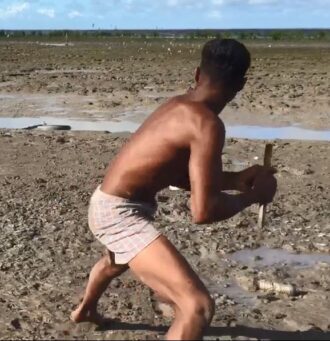 Hunting using the “shocking” technique. A vertical stick is used to pull a horizontal wire taunt as birds take off from the mudflat. (photo: Leon Moore)[/caption]
Andres and colleagues returned to the 55 sites that Bayney surveyed in her earlier study and added five additional sites, to document continued shorebird hunting over the last two decades. Between August–October 2017 and October–November 2018, they visited 60 sites. At each site, they assessed potential shorebird habitat (e.g., mudflats/sand flats versus mangroves) and, if the site was suitable, counted the number of shorebirds present and the species composition of the flocks. The researchers also searched for evidence of hunting. If they didn’t see hunting directly, they asked local community members about their knowledge of current hunting activity in the area.
The researchers returned in 2020, to focus on sites where they had documented hunting in 2017 and 2018. They visited sites every two weeks on Fridays and weekends between late August and early November. The choice of time of the week was intentional. Markets, where shorebirds might be sold, operate on weekends. During the 2020 field season, the researchers interviewed shorebird hunters at two sites and vendors at a local market. They used a questionnaire adapted from one used previously to interview shorebird harvesters in Brazil, French Guiana, and Suriname. All interviewees provided informed consent to be interviewed, remained anonymous, and were interviewed by Guyanese nationals.
To analyse and extrapolate the interview data, the researchers employed a statistical method – Bayesian hierarchical modelling – that can integrate observed data and uncertainty across several different levels of observation. This analysis allowed them to estimate the number of active hunting groups and the number of birds killed at the study sites on days when the researchers were not physically there to make observations.
Results indicated that only 28 of the 60 sites visited by the researchers still contained habitat suitable for shorebirds. Of the sites where suitable habitat was still present, the researchers focused on the 19 sites where the most shorebirds were found, to study species composition and temporal trends. They detected 18 species of shorebird. Small Calidris sandpipers made up 92.6% of all shorebirds counted and the majority of these were Semipalmated Sandpipers Calidris pusilla. Other species that made up more than 1% of the total count were Tringa sandpipers (mainly Lesser Yellowlegs T. flavipes) and Semipalmated Plovers Charadrius semipalmatus.
In terms of hunting, the shocking method was detected at six of the 60 sites visited in 2017–2018, and shooting, as an alternative method of hunting, was also observed at one of these six sites. The researchers also recorded shocking in an abandoned rice field, now used to farm shrimp, where flooded fields attract resting shorebirds during high tide. This site was not one of the six study sites where shocking was detected, but rather an additional and opportunistic observation, and the only site where shorebirds were hunted away from the shoreline. When surveying the markets, the researchers found shorebirds for sale at the Mon Repos and Port Mourant markets in 2017– 2018, with up to 1,000 shorebirds being sold on one occasion. In 2020, the researchers observed shocking on a regular basis at two sites and, at much lower levels than found in 2017–2018, at a third site. They also found shorebirds for sale at the Port Mourant market.
These results suggest that shorebird hunting decreased between the surveys done in 2005 and this current study. In Bayney’s 2005 study, hunting was recorded at 40 of 55 sites (73%) compared to only six of 60 (10%) of sites in 2017–2018. However, a large part of this decrease is likely due to the fact that the Guyanese coastline changed dramatically in the last decades, greatly decreasing the amount of suitable shorebird habitat. More than half (53%) of the sites visited in 2017–2018 no longer provided suitable habitat for shorebirds due to mangrove forestation, erosion, or sand deposition. What is relevant then, is the hunting recorded at sites where shorebird habitat was available, hence six of 28 sites (21%) in 2017–2018. Even taking this into account, there is still a decrease, and the authors point out that socio-economic or cultural factors beyond the scope of their study might have contributed. However, they warn that direct comparison across time is tenuous because survey methods differed between their study and Bayney’s. What they did say with certainty, is that shorebird hunting has not increased in Guyana in the last two decades.
In addition to shorebird counts and recording instances of hunting, the researchers interviewed 10 shockers in 2020. All of those interviewed said that they only harvested shorebirds during fall migration and used the shorebirds they killed for personal consumption. Some additionally said that they sold shorebirds directly to local restaurants or to other people in the community, but none said that they supplied shorebirds to commercial vendors at the Port Mourant market. Nevertheless, in 2020 the researchers found at least 13 species of shorebird for sale at Port Mourant.
[caption id="attachment_16008" align="aligncenter" width="330"]
Hunting using the “shocking” technique. A vertical stick is used to pull a horizontal wire taunt as birds take off from the mudflat. (photo: Leon Moore)[/caption]
Andres and colleagues returned to the 55 sites that Bayney surveyed in her earlier study and added five additional sites, to document continued shorebird hunting over the last two decades. Between August–October 2017 and October–November 2018, they visited 60 sites. At each site, they assessed potential shorebird habitat (e.g., mudflats/sand flats versus mangroves) and, if the site was suitable, counted the number of shorebirds present and the species composition of the flocks. The researchers also searched for evidence of hunting. If they didn’t see hunting directly, they asked local community members about their knowledge of current hunting activity in the area.
The researchers returned in 2020, to focus on sites where they had documented hunting in 2017 and 2018. They visited sites every two weeks on Fridays and weekends between late August and early November. The choice of time of the week was intentional. Markets, where shorebirds might be sold, operate on weekends. During the 2020 field season, the researchers interviewed shorebird hunters at two sites and vendors at a local market. They used a questionnaire adapted from one used previously to interview shorebird harvesters in Brazil, French Guiana, and Suriname. All interviewees provided informed consent to be interviewed, remained anonymous, and were interviewed by Guyanese nationals.
To analyse and extrapolate the interview data, the researchers employed a statistical method – Bayesian hierarchical modelling – that can integrate observed data and uncertainty across several different levels of observation. This analysis allowed them to estimate the number of active hunting groups and the number of birds killed at the study sites on days when the researchers were not physically there to make observations.
Results indicated that only 28 of the 60 sites visited by the researchers still contained habitat suitable for shorebirds. Of the sites where suitable habitat was still present, the researchers focused on the 19 sites where the most shorebirds were found, to study species composition and temporal trends. They detected 18 species of shorebird. Small Calidris sandpipers made up 92.6% of all shorebirds counted and the majority of these were Semipalmated Sandpipers Calidris pusilla. Other species that made up more than 1% of the total count were Tringa sandpipers (mainly Lesser Yellowlegs T. flavipes) and Semipalmated Plovers Charadrius semipalmatus.
In terms of hunting, the shocking method was detected at six of the 60 sites visited in 2017–2018, and shooting, as an alternative method of hunting, was also observed at one of these six sites. The researchers also recorded shocking in an abandoned rice field, now used to farm shrimp, where flooded fields attract resting shorebirds during high tide. This site was not one of the six study sites where shocking was detected, but rather an additional and opportunistic observation, and the only site where shorebirds were hunted away from the shoreline. When surveying the markets, the researchers found shorebirds for sale at the Mon Repos and Port Mourant markets in 2017– 2018, with up to 1,000 shorebirds being sold on one occasion. In 2020, the researchers observed shocking on a regular basis at two sites and, at much lower levels than found in 2017–2018, at a third site. They also found shorebirds for sale at the Port Mourant market.
These results suggest that shorebird hunting decreased between the surveys done in 2005 and this current study. In Bayney’s 2005 study, hunting was recorded at 40 of 55 sites (73%) compared to only six of 60 (10%) of sites in 2017–2018. However, a large part of this decrease is likely due to the fact that the Guyanese coastline changed dramatically in the last decades, greatly decreasing the amount of suitable shorebird habitat. More than half (53%) of the sites visited in 2017–2018 no longer provided suitable habitat for shorebirds due to mangrove forestation, erosion, or sand deposition. What is relevant then, is the hunting recorded at sites where shorebird habitat was available, hence six of 28 sites (21%) in 2017–2018. Even taking this into account, there is still a decrease, and the authors point out that socio-economic or cultural factors beyond the scope of their study might have contributed. However, they warn that direct comparison across time is tenuous because survey methods differed between their study and Bayney’s. What they did say with certainty, is that shorebird hunting has not increased in Guyana in the last two decades.
In addition to shorebird counts and recording instances of hunting, the researchers interviewed 10 shockers in 2020. All of those interviewed said that they only harvested shorebirds during fall migration and used the shorebirds they killed for personal consumption. Some additionally said that they sold shorebirds directly to local restaurants or to other people in the community, but none said that they supplied shorebirds to commercial vendors at the Port Mourant market. Nevertheless, in 2020 the researchers found at least 13 species of shorebird for sale at Port Mourant.
[caption id="attachment_16008" align="aligncenter" width="330"] Shorebirds for sale at the Port Mourant market. (photos: Leon Moore)[/caption]
The species for sale reflected the composition of species found in the counts conducted along the coast. The birds for sale were mainly small Calidris sandpipers, but also larger species such as Greater Yellowlegs Tringa melanoleuca, Black-bellied Plovers Pluvialis squatarola, and Whimbrels Numenius phaeopus. This makes sense since, as a hunting method, shocking is effective for small and large shorebirds alike.
Given that the shockers interviewed in 2020 did not sell shorebirds to the markets, yet the researchers found shorebirds for sale at the market in abundance, the field study clearly could not measure all instances of shorebird hunting or selling. Models, however, were able to extrapolate the information gathered during interviews and to estimate that approximately 37,000 shorebirds were harvested at two sites and sold in one market during the 2020 study period. Given the limited scale of the study in 2020, the total harvest along Guyana’s entire coast was undoubtedly greater.
The magnitude of harvest in Guyana is second only to Suriname and exceeds that of all Caribbean islands combined. 3 The lack of a national policy to regulate this harvest is a challenge to sustainable hunting in Guyana and ultimately throughout the region. This broader context is important because each country is a link in the chain that is a migrant’s journey. Migrating shorebirds are subject to the policies of all of the countries they visit, sequentially. Watts and Turin provided a synthesis of hunting policies across the Western Atlantic Flyway.4 Even if each country sets sustainable limits, the cumulative number of individuals killed along an entire migratory route – the collective harvest – might be too high.5
Andres and colleagues show that shorebird hunting in Guyana is significant and may account for a substantial portion of mortality from hunting in the Caribbean and northern South America. Laws that limit or ban shorebird hunting would help to sustain shorebird populations; however, people have reasons for hunting shorebirds. What would the social and financial consequences be for local people? Though the shocking method for hunting is lethal, the researchers found strings of live birds sold by vendors in the market. Those birds were likely netted – a non-lethal way of catching birds. Can hunting skills be repurposed in a way that saves birds, helps science, and still contributes to the livelihood of locals? This study does not answer these questions, and the authors acknowledge that more research is needed to understand the social aspects of shorebird hunting and its economic impact. Science builds knowledge, study after study, and for shorebird conservation to work, it must respect the needs of local hunters, vendors and conservationists.
Shorebirds for sale at the Port Mourant market. (photos: Leon Moore)[/caption]
The species for sale reflected the composition of species found in the counts conducted along the coast. The birds for sale were mainly small Calidris sandpipers, but also larger species such as Greater Yellowlegs Tringa melanoleuca, Black-bellied Plovers Pluvialis squatarola, and Whimbrels Numenius phaeopus. This makes sense since, as a hunting method, shocking is effective for small and large shorebirds alike.
Given that the shockers interviewed in 2020 did not sell shorebirds to the markets, yet the researchers found shorebirds for sale at the market in abundance, the field study clearly could not measure all instances of shorebird hunting or selling. Models, however, were able to extrapolate the information gathered during interviews and to estimate that approximately 37,000 shorebirds were harvested at two sites and sold in one market during the 2020 study period. Given the limited scale of the study in 2020, the total harvest along Guyana’s entire coast was undoubtedly greater.
The magnitude of harvest in Guyana is second only to Suriname and exceeds that of all Caribbean islands combined. 3 The lack of a national policy to regulate this harvest is a challenge to sustainable hunting in Guyana and ultimately throughout the region. This broader context is important because each country is a link in the chain that is a migrant’s journey. Migrating shorebirds are subject to the policies of all of the countries they visit, sequentially. Watts and Turin provided a synthesis of hunting policies across the Western Atlantic Flyway.4 Even if each country sets sustainable limits, the cumulative number of individuals killed along an entire migratory route – the collective harvest – might be too high.5
Andres and colleagues show that shorebird hunting in Guyana is significant and may account for a substantial portion of mortality from hunting in the Caribbean and northern South America. Laws that limit or ban shorebird hunting would help to sustain shorebird populations; however, people have reasons for hunting shorebirds. What would the social and financial consequences be for local people? Though the shocking method for hunting is lethal, the researchers found strings of live birds sold by vendors in the market. Those birds were likely netted – a non-lethal way of catching birds. Can hunting skills be repurposed in a way that saves birds, helps science, and still contributes to the livelihood of locals? This study does not answer these questions, and the authors acknowledge that more research is needed to understand the social aspects of shorebird hunting and its economic impact. Science builds knowledge, study after study, and for shorebird conservation to work, it must respect the needs of local hunters, vendors and conservationists.
Coastline of East Berbice, Guyana. (photo: Leon Moore)[/caption]
Guyana is a tropical country located in South America between Venezuela and Suriname. Its coastal plain occupies only about 10% of the country’s area, yet 90% of its population lives there. A small portion of this population hunts shorebirds as part of the bounty the coast provides. The primary method for hunting shorebirds on the Guyanese coast is known locally as “shocking”, and the authors described its practitioners as “shockers”. As part of her 2005 Bachelor’s thesis research, Annalise Bayney confirmed the continued use of this method in the new millennium and provided a description of how shocking is conducted.2 A 12- to 15-meter length of stiff wire is attached to a short stick inserted into the sand or mud. As a flock of birds skims the surface of the shore, the wire is pulled taut horizontally, cutting into the flock. The tension of the wire kills the birds, sometimes removing appendages in the process.
[caption id="attachment_16007" align="aligncenter" width="330"] Hunting using the “shocking” technique. A vertical stick is used to pull a horizontal wire taunt as birds take off from the mudflat. (photo: Leon Moore)[/caption]
Andres and colleagues returned to the 55 sites that Bayney surveyed in her earlier study and added five additional sites, to document continued shorebird hunting over the last two decades. Between August–October 2017 and October–November 2018, they visited 60 sites. At each site, they assessed potential shorebird habitat (e.g., mudflats/sand flats versus mangroves) and, if the site was suitable, counted the number of shorebirds present and the species composition of the flocks. The researchers also searched for evidence of hunting. If they didn’t see hunting directly, they asked local community members about their knowledge of current hunting activity in the area.
The researchers returned in 2020, to focus on sites where they had documented hunting in 2017 and 2018. They visited sites every two weeks on Fridays and weekends between late August and early November. The choice of time of the week was intentional. Markets, where shorebirds might be sold, operate on weekends. During the 2020 field season, the researchers interviewed shorebird hunters at two sites and vendors at a local market. They used a questionnaire adapted from one used previously to interview shorebird harvesters in Brazil, French Guiana, and Suriname. All interviewees provided informed consent to be interviewed, remained anonymous, and were interviewed by Guyanese nationals.
To analyse and extrapolate the interview data, the researchers employed a statistical method – Bayesian hierarchical modelling – that can integrate observed data and uncertainty across several different levels of observation. This analysis allowed them to estimate the number of active hunting groups and the number of birds killed at the study sites on days when the researchers were not physically there to make observations.
Results indicated that only 28 of the 60 sites visited by the researchers still contained habitat suitable for shorebirds. Of the sites where suitable habitat was still present, the researchers focused on the 19 sites where the most shorebirds were found, to study species composition and temporal trends. They detected 18 species of shorebird. Small Calidris sandpipers made up 92.6% of all shorebirds counted and the majority of these were Semipalmated Sandpipers Calidris pusilla. Other species that made up more than 1% of the total count were Tringa sandpipers (mainly Lesser Yellowlegs T. flavipes) and Semipalmated Plovers Charadrius semipalmatus.
In terms of hunting, the shocking method was detected at six of the 60 sites visited in 2017–2018, and shooting, as an alternative method of hunting, was also observed at one of these six sites. The researchers also recorded shocking in an abandoned rice field, now used to farm shrimp, where flooded fields attract resting shorebirds during high tide. This site was not one of the six study sites where shocking was detected, but rather an additional and opportunistic observation, and the only site where shorebirds were hunted away from the shoreline. When surveying the markets, the researchers found shorebirds for sale at the Mon Repos and Port Mourant markets in 2017– 2018, with up to 1,000 shorebirds being sold on one occasion. In 2020, the researchers observed shocking on a regular basis at two sites and, at much lower levels than found in 2017–2018, at a third site. They also found shorebirds for sale at the Port Mourant market.
These results suggest that shorebird hunting decreased between the surveys done in 2005 and this current study. In Bayney’s 2005 study, hunting was recorded at 40 of 55 sites (73%) compared to only six of 60 (10%) of sites in 2017–2018. However, a large part of this decrease is likely due to the fact that the Guyanese coastline changed dramatically in the last decades, greatly decreasing the amount of suitable shorebird habitat. More than half (53%) of the sites visited in 2017–2018 no longer provided suitable habitat for shorebirds due to mangrove forestation, erosion, or sand deposition. What is relevant then, is the hunting recorded at sites where shorebird habitat was available, hence six of 28 sites (21%) in 2017–2018. Even taking this into account, there is still a decrease, and the authors point out that socio-economic or cultural factors beyond the scope of their study might have contributed. However, they warn that direct comparison across time is tenuous because survey methods differed between their study and Bayney’s. What they did say with certainty, is that shorebird hunting has not increased in Guyana in the last two decades.
In addition to shorebird counts and recording instances of hunting, the researchers interviewed 10 shockers in 2020. All of those interviewed said that they only harvested shorebirds during fall migration and used the shorebirds they killed for personal consumption. Some additionally said that they sold shorebirds directly to local restaurants or to other people in the community, but none said that they supplied shorebirds to commercial vendors at the Port Mourant market. Nevertheless, in 2020 the researchers found at least 13 species of shorebird for sale at Port Mourant.
[caption id="attachment_16008" align="aligncenter" width="330"] Shorebirds for sale at the Port Mourant market. (photos: Leon Moore)[/caption]
The species for sale reflected the composition of species found in the counts conducted along the coast. The birds for sale were mainly small Calidris sandpipers, but also larger species such as Greater Yellowlegs Tringa melanoleuca, Black-bellied Plovers Pluvialis squatarola, and Whimbrels Numenius phaeopus. This makes sense since, as a hunting method, shocking is effective for small and large shorebirds alike.
Given that the shockers interviewed in 2020 did not sell shorebirds to the markets, yet the researchers found shorebirds for sale at the market in abundance, the field study clearly could not measure all instances of shorebird hunting or selling. Models, however, were able to extrapolate the information gathered during interviews and to estimate that approximately 37,000 shorebirds were harvested at two sites and sold in one market during the 2020 study period. Given the limited scale of the study in 2020, the total harvest along Guyana’s entire coast was undoubtedly greater.
The magnitude of harvest in Guyana is second only to Suriname and exceeds that of all Caribbean islands combined. 3 The lack of a national policy to regulate this harvest is a challenge to sustainable hunting in Guyana and ultimately throughout the region. This broader context is important because each country is a link in the chain that is a migrant’s journey. Migrating shorebirds are subject to the policies of all of the countries they visit, sequentially. Watts and Turin provided a synthesis of hunting policies across the Western Atlantic Flyway.4 Even if each country sets sustainable limits, the cumulative number of individuals killed along an entire migratory route – the collective harvest – might be too high.5
Andres and colleagues show that shorebird hunting in Guyana is significant and may account for a substantial portion of mortality from hunting in the Caribbean and northern South America. Laws that limit or ban shorebird hunting would help to sustain shorebird populations; however, people have reasons for hunting shorebirds. What would the social and financial consequences be for local people? Though the shocking method for hunting is lethal, the researchers found strings of live birds sold by vendors in the market. Those birds were likely netted – a non-lethal way of catching birds. Can hunting skills be repurposed in a way that saves birds, helps science, and still contributes to the livelihood of locals? This study does not answer these questions, and the authors acknowledge that more research is needed to understand the social aspects of shorebird hunting and its economic impact. Science builds knowledge, study after study, and for shorebird conservation to work, it must respect the needs of local hunters, vendors and conservationists.
- Andres, B.A., L. Moore, A.R. Cox, B. Frei & C. Roy. 2022. A preliminary assessment of shorebird harvest in coastal Guyana. Wader Study 129(1): 39–47.
- Bayney, A. 2005. The effect of birding on local and migrant waterfowl populations along the coast of Guyana. Bachelor’s Thesis, University of Guyana, Guyana.
- AFSI Harvest Working Group. 2020. Actions for the Atlantic Flyway Shorebird Initiative’s Shorebird Harvest Working Group 2020–2025. U.S. Fish & Wildlife Service, Migratory Bird Program, Falls Church, VA, USA.
- Watts, B. D. & C. Turrin. 2016. Assessing Hunting Policies for Migratory Shorebirds throughout the Western Hemisphere. Wader Study 123(1): 6-15.
- Watts, B. D., E. T. Reed & C. Turrin. 2015. Estimating sustainable mortality limits for shorebirds using the Western Atlantic Flyway. Wader Study 122(1): 37–53.
Spotlight: Shorebird Hunting in Guyana
Posted by Gwenaël Quaintenne on 5 May 2022
By Deborah Buehler People catch shorebirds for many reasons; some for research and study, others as a supplemental food source. The Caribbean coast is rich in birdlife, and all along this coast, including the islands and the northern shores of South America, shorebirds have been hunted for food. This cultural tradition has gone on for centuries. For some people, it is a practical way to make ends meet, but others worry about whether the hunting affects shorebird populations. How many birds are
We are pleased to annouce the results of the first IWSG T-shirt competition! We had a wonderful range of designs sent in and thought it was a tough decision, the ExCo Judging panel voted that Chris Heward's "Vanellus" design was the winner!
This design can be found on both a standard and fitted style of t-shirt and on a tote bag. Chris will be getting one of these t-shirts himself and has won a year's members to the IWSG.
[caption id="attachment_15899" align="aligncenter" width="330"] Chris Heward created this design for our winter 2021 IWSG t-shirt contest and won! He was declared the outright winner and we thank him for his faboulous design.[/caption]
In second place is Alex Dodds with her "Hidden Waders", a wonderfully clever design that the judging panel really liked too. Again this design can be found on standard and fitted t-shirt as well as a tote bag. Alex will be winning a copy of her design on a tote bag as runner up.
[caption id="attachment_15902" align="aligncenter" width="330"]
Chris Heward created this design for our winter 2021 IWSG t-shirt contest and won! He was declared the outright winner and we thank him for his faboulous design.[/caption]
In second place is Alex Dodds with her "Hidden Waders", a wonderfully clever design that the judging panel really liked too. Again this design can be found on standard and fitted t-shirt as well as a tote bag. Alex will be winning a copy of her design on a tote bag as runner up.
[caption id="attachment_15902" align="aligncenter" width="330"] This is the running up design by Alex Dodds and shows her lovely use of perspective to hide a world of waders into the outline of another.[/caption]
There were so many lovely designs in this completitions that we've decided to also put up three other designs that were Highly Commended by the panel. These are (in no particular order): Shawkat Khan's "Wader Group", Camilo Carneiro's "Whimbrel" and Marc Giles' "Plover Lover".
[caption id="attachment_15905" align="aligncenter" width="330"]
This is the running up design by Alex Dodds and shows her lovely use of perspective to hide a world of waders into the outline of another.[/caption]
There were so many lovely designs in this completitions that we've decided to also put up three other designs that were Highly Commended by the panel. These are (in no particular order): Shawkat Khan's "Wader Group", Camilo Carneiro's "Whimbrel" and Marc Giles' "Plover Lover".
[caption id="attachment_15905" align="aligncenter" width="330"] From left to right, winners of our inaugural t-shirt design competition run during the winter of 2021-2022: 'Whimbrel' design by Camilo Carneiro, 'Wader Group' by Shawkat Khan and 'Plover Lover' by Marc Gilles.[/caption]
Please visit our Teemill website to see the final designs and we hope you are tempted to buy one (or two!):
https://waderstudygroup.teemill.com/collection/iwsg-t-shirt-competition-winter-2021/
From left to right, winners of our inaugural t-shirt design competition run during the winter of 2021-2022: 'Whimbrel' design by Camilo Carneiro, 'Wader Group' by Shawkat Khan and 'Plover Lover' by Marc Gilles.[/caption]
Please visit our Teemill website to see the final designs and we hope you are tempted to buy one (or two!):
https://waderstudygroup.teemill.com/collection/iwsg-t-shirt-competition-winter-2021/
Chris Heward created this design for our winter 2021 IWSG t-shirt contest and won! He was declared the outright winner and we thank him for his faboulous design.[/caption]
In second place is Alex Dodds with her "Hidden Waders", a wonderfully clever design that the judging panel really liked too. Again this design can be found on standard and fitted t-shirt as well as a tote bag. Alex will be winning a copy of her design on a tote bag as runner up.
[caption id="attachment_15902" align="aligncenter" width="330"] This is the running up design by Alex Dodds and shows her lovely use of perspective to hide a world of waders into the outline of another.[/caption]
There were so many lovely designs in this completitions that we've decided to also put up three other designs that were Highly Commended by the panel. These are (in no particular order): Shawkat Khan's "Wader Group", Camilo Carneiro's "Whimbrel" and Marc Giles' "Plover Lover".
[caption id="attachment_15905" align="aligncenter" width="330"] From left to right, winners of our inaugural t-shirt design competition run during the winter of 2021-2022: 'Whimbrel' design by Camilo Carneiro, 'Wader Group' by Shawkat Khan and 'Plover Lover' by Marc Gilles.[/caption]
Please visit our Teemill website to see the final designs and we hope you are tempted to buy one (or two!):
https://waderstudygroup.teemill.com/collection/iwsg-t-shirt-competition-winter-2021/ Results of the IWSG t-shirt competition
Posted by Gwenaël Quaintenne on 2 March 2022
We are pleased to annouce the results of the first IWSG T-shirt competition! We had a wonderful range of designs sent in and thought it was a tough decision, the ExCo Judging panel voted that Chris Heward's "Vanellus" design was the winner! This design can be found on both a standard and fitted style of t-shirt and on a tote bag. Chris will be getting one of these t-shirts himself and has won a year's members to the IWSG. In second place is Alex Dodds with her "Hidden Waders", a
by Deborah Buehler originally published in Wader Study 128(3)
It’s hard to ignore climate change these days. Heatwaves are hotter, floods are fiercer, and some part of the planet is always on fire. In the Arctic, ecosystems based on snow, ice and permafrost are disappearing. These habitats are important breeding grounds for many migratory bird species, particularly waders, and they are vanishing before scientists can determine what the birds need most to survive.
Breeding waders are notoriously difficult to study because their nests are well camouflaged and spread out over huge swaths of largely inaccessible tundra. This is where technological advances can help. In this issue of Wader Study, Hoefs and colleagues combine powerful machine-learning algorithms with remote sensing data to build a statistical model that can predict the breeding distribution of the Eurasian Dotterel Charadrius morinellus in northern Sweden.1
Dotterels are medium-sized waders with striking white eye-stripes and a dove-like appearance. They breed on Arctic or alpine tundra from Scotland to western Alaska, then migrate south to non-breeding areas from North Africa to Iran.
[caption id="attachment_15867" align="aligncenter" width="330"] A pair of Eurasian Dotterel Charadrius morinellus in the tundra of northern Sweden. (photo: Christian Hoefs).[/caption]
Like many wader species, Dotterel populations are declining, and this species is especially vulnerable because it is specialized to a narrow ecological niche. This same quality makes it an ideal species to study using machine-learning based algorithms.
Hoefs and colleagues wanted to use such algorithms to build maps showing where suitable habitat for Dotterels is located. They also wanted to determine which environmental variables, in freely-available remote sensing data, best predicted where Dotterels breed. To do this they used a statistical technique called maximum entropy (or MaxEnt) modelling. MaxEnt is a method that can predict where birds and other organisms are most likely to be located (their distribution) using limited field data. While most predictive methods need to be trained on input about both where the organisms usually are (presence) and where they are not (absence), MaxEnt requires presence data only.2 This is good news, because it is easier to gather reliable data on presence than absence. For example, finding a bird, or a nest, definitively indicates presence, but not finding a nest, amid a huge swath of tundra, doesn’t necessarily mean the birds aren’t there.
To gather presence data, the researchers surveyed two study areas (~10 km² in total) in the Vindelfjällen Nature Reserve in Swedish Lapland several times during each breeding season from 2016 to 2018. Each visit lasted a full day and a team of three to six people walked through the area in systematic lines regularly scanning with binoculars for birds displaying or showing breeding behavior. This work resulted in a dataset of 23 Dotterel nests and 156 locations where birds were found exhibiting breeding behavior.
In the world of statistical modelling, this is a relatively small dataset. The researchers also knew that they were searching for birds in locations that were, necessarily, more accessible to humans (biased sampling) and therefore tended to have similar characteristics (spatial autocorrelation). Luckily, the MaxEnt method can handle small datasets2 and biased sampling effort, as long the minimum distance between presence points is set to a coarser scale than predictor variables.3 To meet this requirement, the researchers excluded presence points that were less than 300m apart. This avoided overrepresenting the habitat preferences of birds in more intensively searched areas.
MaxEnt modelling also requires a set of environmental variables that describe the suitability of the environment for the species. For this, Hoefs and colleagues used Sentinel-2A satellite data. They needed temporal correspondence between the environmental data and the period when parents raise their chicks, so they used data from July 2018, around the egg hatching date of Dotterels in the area. The satellite data yielded vegetation metrics, texture metrics (grey level textures that show similarities or differences in contrast), and topographic variables.
The next step was to determine which of the over 200 environmental variables would provide the best combination of predictors. Often, researchers pre-select variables based on expert knowledge about the biology of the species. But newer techniques, which include everything and then filter to a subset of highly contributing variables, perform better.4 The researchers chose this second approach and started with a model that included all available variables. To prune this model, they first removed variables that contributed less than 2%. Then they identified the best-performing variable and removed all variables that were correlated with that variable (the variables change together in similar ways), then repeated with the second-best performing variable and so forth. This process trimmed the set of 211 environmental variables to seven uncorrelated and highly contributing predictors.
The researchers now had everything they needed to predict the location of suitable habitat for Dotterel. They used MaxEnt to find the probability distribution of maximum entropy (the most spread out) by comparing known locations of presence against 8,000 background samples randomly distributed over the entire nature reserve to represent potentially unsuitable habitats.
The model and maps predicted that about 1% of the total area of the nature reserve (about 60 km²) is suitable habitat for Dotterel. The researchers built and tested their model based on a well-surveyed study area of about 10 km² with about 30 breeding pairs of Dotterel. Extrapolating, this predicts a breeding population of about 180 pairs in the entire nature reserve.
Scientists are a skeptical bunch, and the researchers wondered if their model could be trusted. After all, the algorithm chose predictor variables like Chlorophyll Vegetation Index and S08 TM Difference Variance 200 m sd that mean little to humans, whereas other variables like altitude, slope, and exposure, were excluded. To check the model’s results for accuracy against the real world, the authors went back to the field in June 2019 and conducted surveys in areas that the model predicted as suitable Dotterel habitat. They also checked the model against 47 presence locations collected through an independent annual survey conducted in the reserve.
The model performed well in the sense that birds were found where they were predicted to be. This result gives some confidence that the variables chosen, and the habitats predicted, by machine-learning are actually important to Dotterels. It also makes sense remembering that the selected variables were highly correlated with things that humans already know are important to Dotterels. The chosen variables might mean less to humans, but they are better predictors of the habitats that Dotterels truly need.
Could this approach also work with other species? Perhaps, though the authors caution that this type of modelling is particularly well suited to species, like Dotterel, with very specific habitat requirements and that predictive power might be lower for generalist species. That said, we need all the tools we can get. We are facing serious challenges with climate change and we’re going to have to rely on technology to help. With appropriate validation, species distribution models combined with climate change models might allow us to better predict shifts in suitable breeding habitat and changes in population size for Arctic-breeding birds of conservation concern.
This study spotlights the potential power of technology, but also reminds us that technology has limits. The authors were careful to work within those limits and to test the technology against known information before relying on it. We need real-life data to train and ground-truth models. Machines can learn, but humans still need to decide what to teach them, and to interpret what they tell us.
1Hoefs, C., T. van der Meer, P. Antkowiak, J. Hagge, M. Green & J. Gottwald. 2021. Exploring the Dotterel Mountains: Improving the understanding of breeding habitat characteristics of an Arctic-breeding specialist bird. Wader Study 128: 226–237.
2Phillips, S.J., R.P. Anderson & R.E. Schapire. 2006. Maximum entropy modeling of species geographic distributions. Ecological Modelling 190: 231–259.
3Fourcade, Y., J.O. Engler, D. Rödder & J. Secondi. 2014. Mapping species distributions with MAXENT using a geographically biased sample of presence data: a performance assessment of methods for correcting sampling bias. PLoS ONE 9: e97122.
4Zeng, Y., B.W. Low & D.C.J. Yeo. 2016. Novel methods to select environmental variables in MaxEnt: A case study using invasive crayfish. Ecological Modelling 341: 5–13.
PDF version of this article is available for download here
Featured Image: Dotterel, Charadrius morinellus, June 2017 ©Hans Norelius from Älvsjö, Sweden.
A pair of Eurasian Dotterel Charadrius morinellus in the tundra of northern Sweden. (photo: Christian Hoefs).[/caption]
Like many wader species, Dotterel populations are declining, and this species is especially vulnerable because it is specialized to a narrow ecological niche. This same quality makes it an ideal species to study using machine-learning based algorithms.
Hoefs and colleagues wanted to use such algorithms to build maps showing where suitable habitat for Dotterels is located. They also wanted to determine which environmental variables, in freely-available remote sensing data, best predicted where Dotterels breed. To do this they used a statistical technique called maximum entropy (or MaxEnt) modelling. MaxEnt is a method that can predict where birds and other organisms are most likely to be located (their distribution) using limited field data. While most predictive methods need to be trained on input about both where the organisms usually are (presence) and where they are not (absence), MaxEnt requires presence data only.2 This is good news, because it is easier to gather reliable data on presence than absence. For example, finding a bird, or a nest, definitively indicates presence, but not finding a nest, amid a huge swath of tundra, doesn’t necessarily mean the birds aren’t there.
To gather presence data, the researchers surveyed two study areas (~10 km² in total) in the Vindelfjällen Nature Reserve in Swedish Lapland several times during each breeding season from 2016 to 2018. Each visit lasted a full day and a team of three to six people walked through the area in systematic lines regularly scanning with binoculars for birds displaying or showing breeding behavior. This work resulted in a dataset of 23 Dotterel nests and 156 locations where birds were found exhibiting breeding behavior.
In the world of statistical modelling, this is a relatively small dataset. The researchers also knew that they were searching for birds in locations that were, necessarily, more accessible to humans (biased sampling) and therefore tended to have similar characteristics (spatial autocorrelation). Luckily, the MaxEnt method can handle small datasets2 and biased sampling effort, as long the minimum distance between presence points is set to a coarser scale than predictor variables.3 To meet this requirement, the researchers excluded presence points that were less than 300m apart. This avoided overrepresenting the habitat preferences of birds in more intensively searched areas.
MaxEnt modelling also requires a set of environmental variables that describe the suitability of the environment for the species. For this, Hoefs and colleagues used Sentinel-2A satellite data. They needed temporal correspondence between the environmental data and the period when parents raise their chicks, so they used data from July 2018, around the egg hatching date of Dotterels in the area. The satellite data yielded vegetation metrics, texture metrics (grey level textures that show similarities or differences in contrast), and topographic variables.
The next step was to determine which of the over 200 environmental variables would provide the best combination of predictors. Often, researchers pre-select variables based on expert knowledge about the biology of the species. But newer techniques, which include everything and then filter to a subset of highly contributing variables, perform better.4 The researchers chose this second approach and started with a model that included all available variables. To prune this model, they first removed variables that contributed less than 2%. Then they identified the best-performing variable and removed all variables that were correlated with that variable (the variables change together in similar ways), then repeated with the second-best performing variable and so forth. This process trimmed the set of 211 environmental variables to seven uncorrelated and highly contributing predictors.
The researchers now had everything they needed to predict the location of suitable habitat for Dotterel. They used MaxEnt to find the probability distribution of maximum entropy (the most spread out) by comparing known locations of presence against 8,000 background samples randomly distributed over the entire nature reserve to represent potentially unsuitable habitats.
The model and maps predicted that about 1% of the total area of the nature reserve (about 60 km²) is suitable habitat for Dotterel. The researchers built and tested their model based on a well-surveyed study area of about 10 km² with about 30 breeding pairs of Dotterel. Extrapolating, this predicts a breeding population of about 180 pairs in the entire nature reserve.
Scientists are a skeptical bunch, and the researchers wondered if their model could be trusted. After all, the algorithm chose predictor variables like Chlorophyll Vegetation Index and S08 TM Difference Variance 200 m sd that mean little to humans, whereas other variables like altitude, slope, and exposure, were excluded. To check the model’s results for accuracy against the real world, the authors went back to the field in June 2019 and conducted surveys in areas that the model predicted as suitable Dotterel habitat. They also checked the model against 47 presence locations collected through an independent annual survey conducted in the reserve.
The model performed well in the sense that birds were found where they were predicted to be. This result gives some confidence that the variables chosen, and the habitats predicted, by machine-learning are actually important to Dotterels. It also makes sense remembering that the selected variables were highly correlated with things that humans already know are important to Dotterels. The chosen variables might mean less to humans, but they are better predictors of the habitats that Dotterels truly need.
Could this approach also work with other species? Perhaps, though the authors caution that this type of modelling is particularly well suited to species, like Dotterel, with very specific habitat requirements and that predictive power might be lower for generalist species. That said, we need all the tools we can get. We are facing serious challenges with climate change and we’re going to have to rely on technology to help. With appropriate validation, species distribution models combined with climate change models might allow us to better predict shifts in suitable breeding habitat and changes in population size for Arctic-breeding birds of conservation concern.
This study spotlights the potential power of technology, but also reminds us that technology has limits. The authors were careful to work within those limits and to test the technology against known information before relying on it. We need real-life data to train and ground-truth models. Machines can learn, but humans still need to decide what to teach them, and to interpret what they tell us.
1Hoefs, C., T. van der Meer, P. Antkowiak, J. Hagge, M. Green & J. Gottwald. 2021. Exploring the Dotterel Mountains: Improving the understanding of breeding habitat characteristics of an Arctic-breeding specialist bird. Wader Study 128: 226–237.
2Phillips, S.J., R.P. Anderson & R.E. Schapire. 2006. Maximum entropy modeling of species geographic distributions. Ecological Modelling 190: 231–259.
3Fourcade, Y., J.O. Engler, D. Rödder & J. Secondi. 2014. Mapping species distributions with MAXENT using a geographically biased sample of presence data: a performance assessment of methods for correcting sampling bias. PLoS ONE 9: e97122.
4Zeng, Y., B.W. Low & D.C.J. Yeo. 2016. Novel methods to select environmental variables in MaxEnt: A case study using invasive crayfish. Ecological Modelling 341: 5–13.
PDF version of this article is available for download here
Featured Image: Dotterel, Charadrius morinellus, June 2017 ©Hans Norelius from Älvsjö, Sweden. Spotlight: MaxEnt Modelling the Dotterel Mountains
Posted by Gwenaël Quaintenne on 3 January 2022
by Deborah Buehler originally published in Wader Study 128(3) It’s hard to ignore climate change these days. Heatwaves are hotter, floods are fiercer, and some part of the planet is always on fire. In the Arctic, ecosystems based on snow, ice and permafrost are disappearing. These habitats are important breeding grounds for many migratory bird species, particularly waders, and they are vanishing before scientists can determine what the birds need most to survive. Breeding waders are
ÉLVONAL Shorebird Science is happy to announce the V. ÉLVONAL conference “Social behaviour, demography and conservation in shorebirds” during 14–15 January 2022, which will be held as an online meeting.
Find attached the conference leaflet as well as the advert to the current PhD position within ÉLVONAL Shorebird Science project:
The conference will focus on current achievements and future plans of ÉLVONAL teams across the globe and will be enriched with targeted webinars.
Any researcher, conservationist or student interested in breeding ecology of shorebirds can use this opportunity to join us from anywhere and discuss recent advances in the field.
The conference participation is free of charge and registration is open until 31 December 2021.
You can register here:
https://forms.gle/rxpGkt7yrTra6PqE9
We are looking forward to meeting you online!
Vojtěch Kubelka
(on the behalf of the organizing team)
Featured image: Puna Plover (Charadrius alticola) together with wintering Baird’s Sandpiper (Calidris bairdii) at Andean altiplano in Peru. © Vojtěch Kubelka
V. ÉLVONAL Conference – virtual event and PhD position advert
Posted by Gwenaël Quaintenne on 7 December 2021
ÉLVONAL Shorebird Science is happy to announce the V. ÉLVONAL conference “Social behaviour, demography and conservation in shorebirds” during 14–15 January 2022, which will be held as an online meeting. Find attached the conference leaflet as well as the advert to the current PhD position within ÉLVONAL Shorebird Science project: V-ELVONAL conference 14-15 January 2022_flyer South Bohemia_CZ_PhD_Breeding ecology The conference will focus on current achievements and future plans of
On behalf of Thomas Lameris & Jeroen Reneerkens
Dear fellow shorebird researchers, We would like to ask for your assistance in a project, where we aim to analyse how chick growth rates of shorebird species worldwide are impacted by changing climatic conditions. Project background and aim Unusual freezing conditions around the globe during this past winter, followed by record-high temperatures in large parts of the Arctic this spring, again form an example that the globe's climate will be more and more governed by extremes. Vulnerability of shorebirds populations to this changing climate has been predicted from modelling efforts, as well as shown by changes in reproductive success and body size for individual populations. It is likely that birds are especially vulnerable to effects of a warming climate and climatic extremes in early life, during the period of chick growth. We would like to initiate a project to compare chick growth rates in all shorebird species, where we want to make comparisons between species, populations / study sites and years, to study how variation in growth rate is possibly explained by climatic variation. For example, we expect that chick growth rate will be lower when chicks face temperatures below or above their thermoneutral zone, or during extreme climatic conditions such as prolonged periods of rainfall. We hope that this project can give us insights into the vulnerability of shorebirds to a warming climate, and whether species and populations may differ in their vulnerability. Request for data We are looking for data on biometrics (body mass, tarsus length, wing length, etc.) measured for shorebird chicks of any shorebird species. While data collected for chicks with known hatch dates is especially helpful, we consider any data to be useful for this project. We are interested in data from all shorebird species, and from as many study sites, populations and years as possible. This means that any data are valuable, also older data and data collected at atypical sites. We want to use these data specifically to answer the research question outlined above, which is expected to result in one, multi-authored publication, to which collaborators sharing data are invited as co-authors. We consider that data on food availability for chicks (e.g. data on arthropod abundance) is an important explanatory variable when studying chick growth. While we first want to focus on a large-scale comparison in relation to climatic variables only, we consider that a second step would be a comparison with data on food availability. If you have such data available for your population, please let us know and we will get in touch with you on this. Also, if you happen to know the existence of (unpublished) data by others, please forward this message and/or let us know. Please get in touch if you have any questions or comments. Best wishes, Thomas Lameris (thomaslameris@gmail.com) & Jeroen Reneerkens (jeroen.reneerkens@nioz.nl)
Request for collaboration: chick growth rates & climatic conditions
Posted by Gwenaël Quaintenne on 1 December 2021
On behalf of Thomas Lameris & Jeroen Reneerkens Dear fellow shorebird researchers, We would like to ask for your assistance in a project, where we aim to analyse how chick growth rates of shorebird species worldwide are impacted by changing climatic conditions. Project background and aim Unusual freezing conditions around the globe during this past winter, followed by record-high temperatures in large parts of the Arctic this spring, again form an example that the globe's climate will
The IWSG Small Project Grants Committee have decided to extend the deadline for application to 15th December 2021.
With this grant we aim to support shorebird studies that otherwise will not go ahead. This could be all sorts of projects related to waders (shorebirds): ecological and/or conservation research, pilot studies looking at biological aspects of a single or a few species, or counts of staging birds at unexplored sites. Or something completely different!
Application is open for IWSG members who have a project idea that could be undertaken if supported with a small amount of money (currently 1000 Euros per project).
About the grant: IWSG Small Projects Grants
The application form: https://www.waderstudygroup.org/wp-content/uploads/2018/11/IWSG-grant-application_28112018_form-Word.doc
The IWSG Small Grant Committee
Yahkat Barshep, Birgita Hansen, Nils Warnock, Vojtěch Kubelka and Jannik Hansen
Featured image: Common Redshank Tringa totanus, April 2017, Lake Geneva, Wisconsin, USA. ©Christoph Müller.
Extended deadline for IWSG Small Project Grant applications
Posted by Gwenaël Quaintenne on 1 December 2021
The IWSG Small Project Grants Committee have decided to extend the deadline for application to 15th December 2021. With this grant we aim to support shorebird studies that otherwise will not go ahead. This could be all sorts of projects related to waders (shorebirds): ecological and/or conservation research, pilot studies looking at biological aspects of a single or a few species, or counts of staging birds at unexplored sites. Or something completely different! Application is open for IWSG