Satellite-tagged Bar-tailed Godwits highlight the importance of the Jiangsu coast, China for migratory shorebirds
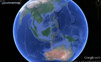
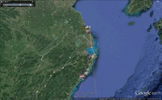
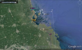
Tracks of all Bar-tailed Godwits (top), and detailed tracks at the Jiangsu coast on 10 April 2017 (below) – a dot indicates the location of the bird when its transmitter was detected by a satellite
Satellite-tagged Bar-tailed Godwits highlight the importance of the Jiangsu coast, China for migratory shorebirds
Five Bar-tailed Godwits, fitted with satellite tags, which departed northwest Australia late March have arrived at the Rudong coast, central Jiangsu Province, China after a 6,000 km flight of appr. 5 days. One bird relies entirely on the worldwide unique Dongsha shoals and the other birds in that region are along the coast off the shoals.
The birds are expected to rest and feed here before continuing to Bohai Bay/northern Yellow Sea where they will fatten up for the final leg of their migration to breeding grounds in Siberia.
The Rudong coast, having some of the largest remaining tidal flats in China, provides a rich fishing ground for people as well as a vital refuelling stop for migrating shorebirds, 15 species of which occur in internationally important numbers – including the Critically Endangered Spoon-billed Sandpiper.
Most of Jiangsu’s intertidal flats are threatened by development plans under which hundreds of square kilometres would be lost to land claim projects, wind farms etc. The Chinese Government, however, announced on 28 February 2017 that the Rudong coast has been placed on a tentative list for nomination as part of a Yellow Sea World Heritage site – recognising the value of the area for migrating birds as well as the unique geological feature of the offshore radial sand ridges.
‘The arrival of these birds further demonstrates the importance of this coastal area for migrating shorebirds’ said (Sir) Professor Theunis Piersma of University of Groningen, who is leading the satellite tagging project. ‘Other birds are still airborne and we await with interest to see where these will make landfall’.
The satellite tagging project is a joint programme of the University of Groningen, the NIOZ Royal Netherlands Institute for Sea Research and the Global Flyway Network, and is supported by the MAVA Foundation, WWF-Netherlands and China, BirdLife International and small private benefactors. For further information contact Yvonne Verkuil at the University of Groningen.